A Smoky Thanksgiving
![]()
Day 1
Into the Hills
Day 2
Train Ride & More
Day 3
Skyway, Knob, & Flume
Day 4
Chicken for Breakfast
On the trip's last day, I had a "finger lickin' good" breakfast, visited a movie set, and went topless.
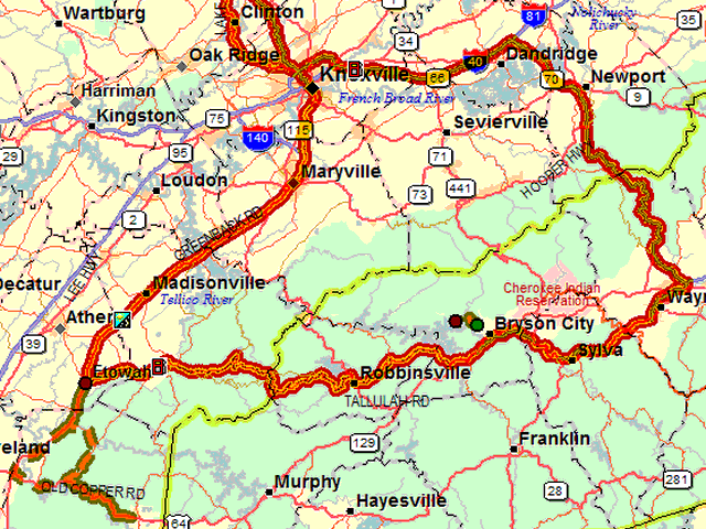
The normal locator map linked to the map icon at the top of the page, encompasses the full trip and much of the wiggliness of the roads between Bryson City and Etowah is lost. For that reason, another map is available here of just the portion south of Knoxville.
November 25, 2006
I started the day with a drive on the Cherohala Skyway, a new favorite
road candidate, and a hike to Huckleberry Knob. I then met Baby Boomer Bob
and wife for lunch and some afternoon exploring.
November 24, 2006
I drove the "Road to Nowhere" took a ride on the Great Smoky Mountains
Railroad, and took in a couple of museums. I got to the western end of the
Blue Ridge Parkway but found it closed.
November 23, 2006
To the south side of the Smoky Mountains on a lot of interstate and a bit
of new - to me - US-25W.
Prelude
Last year's Thanksgiving weekend was a successful experiment. Some still
consider heading out over the fourth Thursday in November for anything
other than a huge meal with friends or family rather odd but I enjoyed the
drive and no one was inconvenienced so I'm again ready to go somewhere.
I only have four days which limits travel to a few hundred miles and south is really the only direction worth considering this time of year. Anything north of Atlanta is probably fair game and that includes several promising places. I've decided on the North Carolina side of the Smoky Mountains. The necessary expressway preamble will take me beyond Knoxville where, if the weather holds, several interesting roads are available.