A Touch of Lincoln
Prev
Next


|
Day 4: May 19, 2008 A Touch of Lincoln |
Prev Next |
|
|
|


 I spent the night in Hancock, Maryland, anticipating a visit to a C &
O Canal Museum in the morning. Apparently any museum is inside the
National Park Service which was not open at 9:30. I drove east on Berm
Road along remnants of the canal. In the second picture, part of the
Potomac Heritage National Scenic Trail can be seen. This section uses the
canal towpath. I know other towpaths have been utilized as hiking trails.
For example, part of Ohio's Buckeye Trail is on the former Miami Erie
Canal towpath. Perhaps this is a movement that, following the lead of
Rails to Trails organizations, will soon be promoted as "Tows to
Toes".
I spent the night in Hancock, Maryland, anticipating a visit to a C &
O Canal Museum in the morning. Apparently any museum is inside the
National Park Service which was not open at 9:30. I drove east on Berm
Road along remnants of the canal. In the second picture, part of the
Potomac Heritage National Scenic Trail can be seen. This section uses the
canal towpath. I know other towpaths have been utilized as hiking trails.
For example, part of Ohio's Buckeye Trail is on the former Miami Erie
Canal towpath. Perhaps this is a movement that, following the lead of
Rails to Trails organizations, will soon be promoted as "Tows to
Toes".
|
|
|
 This circa 1822 Bank Road toll house is just west of Hancock. I've been
here before and had driven by it east bound on Friday. I didn't plan a
visit today but the road I followed along the canal lead me directly here.
This circa 1822 Bank Road toll house is just west of Hancock. I've been
here before and had driven by it east bound on Friday. I didn't plan a
visit today but the road I followed along the canal lead me directly here.
|
|
|


 I had vague plans to just return home the way I had come but, as I looked
at the map Sunday night, I realized that I could add some variety, for
little or no miles, by heading north and picking up the Lincoln Highway at
Breezewood. I did just that and found this breakfast spot near Everett.
Good food and good service from a very friendly staff but the "scenic
view" part of the name was a bit of a mystery. Only a couple of
booths even allowed diners a look outside and their view (of a golf
course) was largely blocked by trees. I'm guessing that view was much
better when the restaurant was named in 1942 and maybe the "scenic
view" included the down the road scene in the second photograph. It
looks pretty good from the parking lot. Somewhat visible in that
"down the road" shot is The Igloo ice cream stand. They weren't
yet open for the day or I'd have had to have some desert for my omelet.
I'm a sucker for buildings with cherries on top. The theater and motel are
in downtown Everett.
I had vague plans to just return home the way I had come but, as I looked
at the map Sunday night, I realized that I could add some variety, for
little or no miles, by heading north and picking up the Lincoln Highway at
Breezewood. I did just that and found this breakfast spot near Everett.
Good food and good service from a very friendly staff but the "scenic
view" part of the name was a bit of a mystery. Only a couple of
booths even allowed diners a look outside and their view (of a golf
course) was largely blocked by trees. I'm guessing that view was much
better when the restaurant was named in 1942 and maybe the "scenic
view" included the down the road scene in the second photograph. It
looks pretty good from the parking lot. Somewhat visible in that
"down the road" shot is The Igloo ice cream stand. They weren't
yet open for the day or I'd have had to have some desert for my omelet.
I'm a sucker for buildings with cherries on top. The theater and motel are
in downtown Everett.
|
|
|
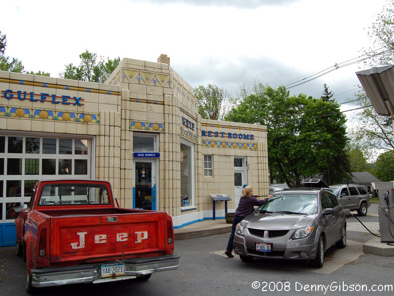
 Just as I had planned from the moment I decided to connect with the
Lincoln, I got my tank filled and my windshield cleaned at what I believe
is my favorite gas station, Dunkle's Gulf in Bedford. For the record, the
gas Sue pumped was $3.89 just like everywhere else in the area. I really
do wish I could give them more business.
Just as I had planned from the moment I decided to connect with the
Lincoln, I got my tank filled and my windshield cleaned at what I believe
is my favorite gas station, Dunkle's Gulf in Bedford. For the record, the
gas Sue pumped was $3.89 just like everywhere else in the area. I really
do wish I could give them more business.
The Coffee Pot at the fairgrounds is almost impossible to pass without stopping to take a picture. I did make this one a little different (Note I did not say better.) by including myself. |
|
|

 A few miles west of Bedford I noticed something labeled "Old Route
30" on the GPS and turned to drive some old - make that very old - road
that I'd not driven before. Its western end is quite near the Lincoln
Motor Court.
A few miles west of Bedford I noticed something labeled "Old Route
30" on the GPS and turned to drive some old - make that very old - road
that I'd not driven before. Its western end is quite near the Lincoln
Motor Court.
|
|
|


 Just some pictures of Pennsylvania countryside. The first is the long
straight west of Schellsburg, the second is from the former site of the
Ship Hotel, and the third was taken on the old alignment east of Stoystown.
Just some pictures of Pennsylvania countryside. The first is the long
straight west of Schellsburg, the second is from the former site of the
Ship Hotel, and the third was taken on the old alignment east of Stoystown.
ADDENDUM: May 22, 2008 - I've been asked about the gas station that once operated across the street from the Ship Hotel. It is certainly no longer operating but I believe this may be the building it occupied. |
|
|


 I visited the Flight 93 Memorial site in 2004 and little has changed since then.
There is a National Park Service sign on the building and Park Service
employees, rather than volunteers, now tend the place but everything looks
much the same. Construction of a permanent memorial may start soon.
I visited the Flight 93 Memorial site in 2004 and little has changed since then.
There is a National Park Service sign on the building and Park Service
employees, rather than volunteers, now tend the place but everything looks
much the same. Construction of a permanent memorial may start soon.
A bus was loading to depart when I arrived and another replaced it before I left. They are supposed to notify the Park Service in advance but, say the guards, they rarely do. When I left, I stopped at the top of the rise north of the site to photograph the view. I saw the bright yellow spot in the distance and could tell early on that it was a semi-tractor. Only when it got closer could I see there was no trailer. Whether the driver was there on business or to visit the memorial, I do not know. |
|
|

 Since I had photographed the number one mile marker at Cumberland, I
decided this would be a good time to capture the number one marker at the
other end and verify the math. Looks right. Then I figured I'd check out
the first marker for the "new" stretch of road across the river
in Ohio and the math looks good there, too.
Since I had photographed the number one mile marker at Cumberland, I
decided this would be a good time to capture the number one marker at the
other end and verify the math. Looks right. Then I figured I'd check out
the first marker for the "new" stretch of road across the river
in Ohio and the math looks good there, too.
|
|
|
| [Prev] [Site Home] [Trip Home] [Contact] [Next] |