Monumental
Prev
Next
|
Day 1: November 22, 2007 Monumental |
Prev Next |
|
|

 Yep. That's a cemetery. And, yes, I'm there geocaching. I'm not going to
make a habit of it but I made a geocommitment and needed to see it
through. About a month ago, when geocaching was all new to me and seemed
so easy I thought a cave man could do it, I picked up a travel bug on a
mission to visit military memorials. Geocaches are hidden containers with
publicized coordinates and travel bugs are small items that folks move
from cache to cache. I quickly identified caches at a few places with
military connections and, just about as quickly, found that two were
"temporarily unavailable" and others were too small to hold much of
anything. One that might have worked was in an area so crowded that I just
gave up. After a weekend of failure, I gave the bug to a geocacher who is
much more active than I but he had no luck either. On Thanksgiving eve, I
took the bug determined to put it somewhere appropriate. This isn't a big
memorial but the cache is named Semper Fidelis and its stated purpose is
to honor all Marines and other military personnel. The
Purple Heart Coin has a new temporary home.
Yep. That's a cemetery. And, yes, I'm there geocaching. I'm not going to
make a habit of it but I made a geocommitment and needed to see it
through. About a month ago, when geocaching was all new to me and seemed
so easy I thought a cave man could do it, I picked up a travel bug on a
mission to visit military memorials. Geocaches are hidden containers with
publicized coordinates and travel bugs are small items that folks move
from cache to cache. I quickly identified caches at a few places with
military connections and, just about as quickly, found that two were
"temporarily unavailable" and others were too small to hold much of
anything. One that might have worked was in an area so crowded that I just
gave up. After a weekend of failure, I gave the bug to a geocacher who is
much more active than I but he had no luck either. On Thanksgiving eve, I
took the bug determined to put it somewhere appropriate. This isn't a big
memorial but the cache is named Semper Fidelis and its stated purpose is
to honor all Marines and other military personnel. The
Purple Heart Coin has a new temporary home.
|
|
|


 Once the cache was re-sealed and re-stashed, it was just a couple of miles
almost due south to the Anderson Ferry. The ferry runs every day except
Christmas. It was delivering a car to the far shore when I arrived
and was soon headed back with another. Then things started picking up. I
was one of two on the next southbound trip and there were three waiting
when we pulled in. On shore, I headed uphill toward the expressway.
Once the cache was re-sealed and re-stashed, it was just a couple of miles
almost due south to the Anderson Ferry. The ferry runs every day except
Christmas. It was delivering a car to the far shore when I arrived
and was soon headed back with another. Then things started picking up. I
was one of two on the next southbound trip and there were three waiting
when we pulled in. On shore, I headed uphill toward the expressway.
I hadn't thought much about routing when I decided this would be a Nashville weekend and went to bed Wednesday with intentions of basically heading there on the expressways. This morning, after a visit to RoadsideAmerica.com, I decided on a less direct route. I left I-65 at Elizabethtown and headed west on US-62. Sixty-Two is a road that I've taken quite a liking to. I've covered all of it east of E-Town but only a scrap or two west of there. I welcomed the opportunity to check out another hundred miles of this road. |
|
|


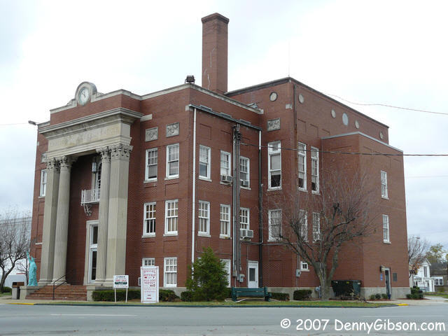 The Grayson County courthouse in Leitchfield is situated in the middle of
the town square much like the one in Elizabethtown and it even looks
somewhat similar. But few courthouses have their own
Statue of Liberty or a sign advertising a
buffalo buffet. The old theater and hotel on
the square look both interesting and promising. The theater's windows
still have masking tape from its most recent paint job but the paint
doesn't look all that fresh. It appears that the project may have been
dropped mid-stride.
The Grayson County courthouse in Leitchfield is situated in the middle of
the town square much like the one in Elizabethtown and it even looks
somewhat similar. But few courthouses have their own
Statue of Liberty or a sign advertising a
buffalo buffet. The old theater and hotel on
the square look both interesting and promising. The theater's windows
still have masking tape from its most recent paint job but the paint
doesn't look all that fresh. It appears that the project may have been
dropped mid-stride.
|
|
|

 Yes, the Kentuckian with a car or three on blocks in the yard is a
cliché but it's not unfounded. This stretch of US-62 has its share of
non-mobile automobiles but most are rather plain looking sedans and pickup
trucks. Here we have a more colorful collection of retired (or at least
resting) race cars.
Yes, the Kentuckian with a car or three on blocks in the yard is a
cliché but it's not unfounded. This stretch of US-62 has its share of
non-mobile automobiles but most are rather plain looking sedans and pickup
trucks. Here we have a more colorful collection of retired (or at least
resting) race cars.
The second picture is of wary survivors of the Thanksgiving Day Massacre. I spotted quite a few wild turkeys in fields along the road. As long as cars are speeding by, they're quite content to stroll along in the open but let a car stop and they instantly dash toward the nearest cover. |
|
|


 A few weeks ago I was in Owensboro looking for the Bluegrass Hall of Fame
when a waitress told me there might be "something" in Rosine. I
did check its general location but not the specifics so had a pleasant
surprise when a Rosine limit sign appeared. The Monroe Brothers, Bluegrass
music's father and uncles, were born just west of town. A half-dozen years
ago, a veterinarian named Campbell Mercer launched a plan to save the
"Old Homestead" which the Monroe family had lost long ago. He
succeeded and today Jerusalem Ridge hosts a major Bluegrass festival and
the restored house is a museum; closed, of course, on Thanksgiving.
The Jerusalem Ridge entrance crosses over the railroad track and a shot
from there provides a good example of how close track and pavement tend
to be along much of this part of US-62.
A few weeks ago I was in Owensboro looking for the Bluegrass Hall of Fame
when a waitress told me there might be "something" in Rosine. I
did check its general location but not the specifics so had a pleasant
surprise when a Rosine limit sign appeared. The Monroe Brothers, Bluegrass
music's father and uncles, were born just west of town. A half-dozen years
ago, a veterinarian named Campbell Mercer launched a plan to save the
"Old Homestead" which the Monroe family had lost long ago. He
succeeded and today Jerusalem Ridge hosts a major Bluegrass festival and
the restored house is a museum; closed, of course, on Thanksgiving.
The Jerusalem Ridge entrance crosses over the railroad track and a shot
from there provides a good example of how close track and pavement tend
to be along much of this part of US-62.
|
|
|

 When I crossed the Green River, I spotted a strange contraption that made
me turn around to check it out. At first sight, I thought it was some sort
of drawbridge. Then I thought it might be something badly mangled by some
frightful force of nature. When I first approached it, I toyed with the
idea that it was a coal loading device but eventually returned to my first
guess. This, I believe, is a railroad drawbridge. That's Muhlenberg County
on the other side of the river. Over there, the air reportedly smells like
snakes you can shoot at with pistols.
When I crossed the Green River, I spotted a strange contraption that made
me turn around to check it out. At first sight, I thought it was some sort
of drawbridge. Then I thought it might be something badly mangled by some
frightful force of nature. When I first approached it, I toyed with the
idea that it was a coal loading device but eventually returned to my first
guess. This, I believe, is a railroad drawbridge. That's Muhlenberg County
on the other side of the river. Over there, the air reportedly smells like
snakes you can shoot at with pistols.
ADDENDUM: Nov 29, 2007 - The snakes line has triggered comments ranging from "Huh?" to "Ewwwwww..." so I reckon a little explanation is in order. It refers to a line from John Prine's ode to Muhlenberg County, Paradise. The line is "Where the air smelled like snakes and we'd shoot with our pistols." The complete lyrics are here. Sorry about the confusion. "I'm just tryin' to have me some fun. Well done, hot dog bun, my sister's a nun." |
|
|

 Some other brothers and another "hometown". Don really was born
just a couple of miles from Central City, Kentucky. Phil was born in
Chicago. In 1988, Central City's Chestnut Street became Everly Brothers
Boulevard. A cool surprise.
Some other brothers and another "hometown". Don really was born
just a couple of miles from Central City, Kentucky. Phil was born in
Chicago. In 1988, Central City's Chestnut Street became Everly Brothers
Boulevard. A cool surprise.
|
|
|


 One of the things RoadsideAmerica turned me onto is the Round Table
Literary Park in Hopkinsville. Besides the table and stoned sword, there
is a Greek amphitheater, the recreated ruins of a Delphian temple, and
other artistic tidbits. The amphitheater includes
stones from area buildings such as high
schools and a church. Nice touch.
One of the things RoadsideAmerica turned me onto is the Round Table
Literary Park in Hopkinsville. Besides the table and stoned sword, there
is a Greek amphitheater, the recreated ruins of a Delphian temple, and
other artistic tidbits. The amphitheater includes
stones from area buildings such as high
schools and a church. Nice touch.
|
|
|


 I have to admit that I knew about this place before this morning and is
kind of the reason I even looked to western Kentucky for this trip. Posted
at the site is a document describing it as the "fourth-highest
monument in the United States"; RoadsideAmerica says fifth. I don't
know which of the others (Gateway Arch, San Jacinto Monument, Washington
Monument, Perry's Victory Memorial) they left out but I do know that this
thing is BIG. What it is is a
monument to Jefferson Davis built in a state that he
left as an infant and that was never part of the Confederacy.
I have to admit that I knew about this place before this morning and is
kind of the reason I even looked to western Kentucky for this trip. Posted
at the site is a document describing it as the "fourth-highest
monument in the United States"; RoadsideAmerica says fifth. I don't
know which of the others (Gateway Arch, San Jacinto Monument, Washington
Monument, Perry's Victory Memorial) they left out but I do know that this
thing is BIG. What it is is a
monument to Jefferson Davis built in a state that he
left as an infant and that was never part of the Confederacy.
I approached from the west on Jefferson Davis Highway which provides a first view of the monument at about a mile and a half. The first picture was taken through the windshield about a half mile away. When open (May 1 - Oct 31), visitors can ride to the top in an elevator and check out a museum and gift shop. There's going to be a big party here in 2008 for JD's 200th. The site also contains the Zero Milestone for the Jefferson Davis Highway visible in the background of the fourth picture. I gather that the monument is more commonly approached from US-68 and the last picture was taken from there; maybe one-third mile away. Yep, that's an Amish buggy turning off of Sixty-Eight. They were out in abundance today. The driver and I exchanged smiles and waves as he passed but I couldn't help thinking that his smile carried a bit of amusement. I'm standing in the road taking pictures of a ridiculously tall obelisk built for a guy known primarily for heading up the losing side in our country's worst conflict. I deserved it. |
|
|
| [Prev] [Site Home] [Trip Home] [Contact] [Next] |