Book Review
Fips, Bots, Doggeries, and More
Tracy Lawson

Fips, Bots, Doggeries, and More coverIn 1990, Tracy Lawson’s parents gave her a stack of twenty-one photocopied pages as a Christmas present. Transcribed onto the typewritten pages was the journal of her third great-grandfather’s 1838 trip from a Cincinnati suburb to New York City. In 2012, Lawson is sharing those pages and the experiences they triggered, in Fips, Bots, Doggeries, and More. The book is comprised of two sections. “Section I — 1838” contains the journal along with Lawson’s illuminating comments and notes. “Section II — 2003-2009” contains accounts of the author’s own trips along the route. Both sections are liberally illustrated with black and white photos and drawings.

The writer of the 1838 journal was Henry Rogers, who operated a successful mill in Mount Pleasant (now Mount Healthy), Ohio. Traveling with the 32 year old Henry were his wife and her parents. The miller was both literate and observant and he sets out to record “…all interesting subjects and things that come under my observation”. The journal provides a most interesting look at nineteenth century road-tripping. Henry recorded expenses and named names so we know, for example, that the group spent a night at Winchester’s hotel in Jefferson (now West Jefferson), Ohio and paid $2.50 for the privilege. That $2.50 covered bed and board for four people and two horses. Along the way, he records expenses for tolls, horseshoes, wagon tyres, and “face barbering”, etc..

The travelers picked up the National Road in Jefferson, Ohio, and followed it and its extensions to Hagerstown, Maryland. As a fan of the National Road, I enjoyed reading Henry’s descriptions and found his pre-bridge entry to Wheeling, Virginia, which required a ferry over each of the two Ohio River channels at costs of 25 and 37.5 cents, especially interesting. They passed through Brownsville, Pennsylvania, during construction of the first cast iron bridge in the United States. It doesn’t appear as if Henry realized that the bridge that would soon carry the National Road over Dunlap’s Creek was the first of its kind but he described it as “splendid” while being forced to cross on an “..old narrow bridge that looked as though it would scarcely bear its own weight.” At Hagerstown, the group turned northeast and headed toward Gettysburg, Pennsylvania, then through Abbottstown and York to Lancaster. Roadies will recognize the Gettysburg to Lancaster route as the future path of the Lincoln Highway. From Lancaster, they continued northeast to Trenton, New Jersey, where they spent a little time and made a visit to Philadelphia before moving onto New York City.

The 1838 journal is accompanied by sidebars that explain unfamiliar terms or provide background for certain passages. The journal’s text is cross referenced to a set of end notes. A subsection titled “Expansions” contains short dissertations on subjects that were part of Henry Rogers’ world. These include mills, finances, politics, medicine, fashion, and more.

The author made three trips specifically to experience and research the route her great-great-great-grandparents had followed. Two were driving trips with her daughter and one was a solo fly-and-drive outing. These trips are covered in “Section II” with a blend of genealogy, personal discovery, and general history. It’s fun reading that mirrors Henry’s journal in the sense that both are straight forward reports of some relatively unscripted travel. Henry’s journal held my interest more but there is a good chance that this was because his travel was so much different from today’s. Lawson describes some of the places she stayed and ate much as Henry did and there is even an encounter with a less than savory character that is reminiscent of some of the “scoundrels and topers” encountered by Henry. But Ramada and Cracker Barrel don’t have the same zing as names like Sign of the Bear and Cross Keys Tavern.

Lawson does locate and visit several of the places mentioned in the journal including a few, such as Pennsylvania’s 7 Stars Inn, that are still operating. She also picked up some information at libraries and local historical societies though the trips were not as rich in field research as she had hoped. They were more successful, it seems, on a personal level. She was able to familiarize herself with the path her ancestors traveled and the world they lived in. The mother-daughter time was, as the ads say, priceless.

That personal connection won’t be there for most readers of Fips, Bots, Doggeries, and More, but it is still an entertaining and informative look at a road trip back when thirty-one and a half cents fed a family of four and two horsepower was plenty.

There are some minor errors. Perhaps I’m just sensitized to this sort of thing but referring to US 36 as State Route 36 and saying the Madonna of the Trail Monuments were “erected … on US Route 40 and US Route 66” with no mention of the National Old Trails Road bothered me. Aside from increased knowledge of her own ancestors and the world of 1838, it seems Tracy Lawson gained some insight into heritage road trips. In the Epilogue she says “And if I were driving the National Road again, I would eat at all the restaurants that were once taverns Henry mentioned in his journal!” I hope she makes that happen.

Fips, Bots, Doggeries, and More, Tracy Lawson, The McDonald & Woodward Publishing Company, April 2012, paperback, 9.1 x 7.1 inches, 156 pages, ISBN 978-1935778196
Available through Amazon.

Music Review
Just Like Honey
Lisa Biales

Just Like Honey CD coverI read somewhere that Alannah Myles recorded her 1989 hit Black Velvet in a hot un-air-conditioned room to make it feel, and therefore sound, like “Mississippi in the middle of a dry spell”. The result was something that could be described in a single word and which fit that word, sultry, in every dimension. Lisa Biales didn’t forego climate control to record Just Like Honey but she did get some help from the south and she did nail SULTRY — dead center and in capital letters.

The title track comes from Nashville song writers Cameron-Beck-Kahan.There are a couple Biales originals, a couple from the CD’s producer, EG Kight, and a Biales-Kight collaboration. Most of the remaining material comes from some of Biales’ musical influences and that was a conscience decision by her and Kight.

If you ask Lisa to name her influences, you best not be in a hurry. The list of female singers she admires and draws from is a long one and includes many who are no strangers to sultry themselves. She doesn’t get to all of them here but she does cover some biggies. There are tunes by Memphis Minnie, Bonnie Raitt, and Candye Kane plus songs written by others but firmly associated with the likes of Ma Rainey, Etta James, and Odetta. And by “cover” I don’t mean “copy”. I mean celebrate and interpret.

A goodly chunk of that “help from the south” I mentioned comes, of course, from Kight, a.k.a, “The Georgia Songbird”. There’s a big dose from Paul Hornsby and his Muscaline Recording Studios in Macon, Georgia, and Capricorn veterans Tommy Talton, Marshall Coats, and Bill Stewart (guitar, bass, drums) contribute their share, too. In fact Talton, supplies a song, Watch Out Baby Don’t Cry, that quickly became a favorite of mine. Talton, Coats, and Stewart form the core group for this CD but others, including Hornsby on keys and Ken Wynn on guitar, show up here and there.

So we have some highly talented musicians, an accomplished producer and engineer, some original material, some material “borrowed” from the best, and maybe even a little of that “slow southern style”. That’s a mighty fine foundation for Lisa’s clear and powerful… and sultry… vocals. Just Like Honey is the name of the CD and of a song that’s on it. It’s also a pretty good description.

The CD is here and Lisa’s website here.


I’ve mentioned a few of Lisa’s live performances in this blog including a couple in April where she and Ronstadt Generations traded “guest appearances”. Ronstadt Generations have just launched a Kickstarter project looking for help with their second studio CD. Check it out here.

Product Review
Route 66 Attractions
with Ready2Go Tours

Route 66 Attractions with Ready2Go ToursMy relationship with Garmin GPS receivers goes back to my first documented road trip in 1999. I haven’t owned a lot of different models and I’m definitely no expert but I’ve used and liked Garmin products for quite awhile. Then, as I traveled with a new unit I bought last April, I began to think that Garmin had completely abandoned me. It took several email exchanges with a fellow named River Pilot to convince me that Garmin still makes products capable of following turn-by-turn routes. Garmin, however, insists on aiming those products at motorcycles. I drive a car.

River Pilot doesn’t work for Garmin. He owns River Pilot Tours, a company offering, among other thing, motorcycle tours of Route 66. They developed the subject of this review. Since River was so helpful in explaining the, in my opinion, warped Garmin product line, I really wanted to like his product but feared I wouldn’t.

I crept up on it. An important thing I learned from River is that there are at least two different types of software inside Garmin GPS units. That inside zūmo®s handles turn-by-turn routing properly; That inside nüvi®s (and other models) does not. By “properly”, I mean the device will not only guide you from point A to point B but will do it along a specific pre-plotted path. The unit I got in April was a nüvi®. I recently bought a zūmo® 220. After a few experiments in the neighborhood, I used it on a trip to Florida and convinced myself that it would indeed follow my routes. Then I bought Route 66 Attractions with Ready2Go Tours.

There are two different River Pilot Tours products available to mate up with the two types of Garmin products. Route 66 Attractions contains more than 800 points of interest (POIs) along Historic Route 66. Each has a description, a photo, and contact information. Almost any current Garmin street product is capable of guiding you to any of the attractions. Then, just as the name implies, Route 66 Attractions with Ready2Go Tours adds turn-by-turn instructions for both east and westbound tours of the route. Both products are published by SpotItOut and both are available for purchase and download at their website. Prices are $30 “with” and $10 “without” although the “with” version is currently on sale for $25.

UPDATE 4-JAN-2014: SpotItOut ceased operation sometime back and River Pilot Tours now sells its products directly on SD cards. The “regular” Route 66 GPS Attractions Guide can be purchased through the online store but the version with Ready2Go Tours cannot. Because not all Garmin GPS units are capable of running the turn-by-turn software, River Pilot Tours requests that potential Ready2Go Tours customers call (307 222 6347) or email (tours@riverspilot.com) so that compatibility can be determined before money is spent.

UPDATE 6-JUL-2014: Both versions of the Route 66 GPS Attractions Guide can now be purchased through the online store. If there is any doubt about compatibility or if there are other questions, just call (307 222 6347) or email (tours@riverspilot.com) for some friendly help. To remove any question of compatibility and avoid the purchase of a high end GPS for one time use, a pre-loaded unit can be rented from River Pilot Tours. Call or email for details.

Purchase, download, and installation were straight forward. The addition to my GPS looked good throughout a bit of playing but it’s really tough to judge a product’s Route 66 turn-by-turn capabilities in a living room in Cincinnati. Last Saturday’s cruise in Illinois provided an opportunity to get a better look.

I was purely a follower on the cruise which meant no one was depending on me and I wasn’t depending on the GPS. At our starting point in Mitchell, I selected the Illinois eastbound tour. I was given a chance to preview the route on a map or read a brief description. When I pressed “GO”, the unit spent a few moments calculating then asked if I would “like to navigate to the start of the Custom Route”. When I pressed “No”, it sat there quietly with a magenta line showing the route on the screen.
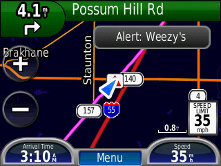
Route 66 Attractions with Ready2Go Tours screen shotAs we cruised northeast through Edwardsville and Hamel, the voice from the GPS essentially described the actions of the cars in front of me. It allowed me to anticipate turns just a bit so I might have even looked like I knew where I was going. The unit beeped when we approached Sixty-Six attractions such as Weezy’s and Decamp Junction. Each of these was identified and I could have pulled up a description if I’d wanted.

Things were going along swimmingly when the caravan made a turn to the right and the voice in the box said nothing. Was this a flaw in the GPS guided tour? Nope. Not at all. It was just a simple fact of life and roads. Over time roads get rerouted and from just south of Staunton to inside the city of Springfield US 66 had two major alignments. The caravan turned right on the newer, post-1930, alignment while the GPS tour continued on the older, 1926-1930, alignment.

The primary purpose of the Ready2Go tour is to guide a traveler from one end of Route 66 to the other. It does just that and it keeps the traveler on some alignment of Route 66 all the way. It will not take you over every mile of every alignment that the route ever followed. For that you will need some maps, some books, perhaps some input from an expert, and a readiness to backtrack and explore. River Pilot Tours had to select one of the two Staunton-Springfield alignments to be part of the “grand tour” and they chose wisely. The older alignment is the more interesting of the two and we would be returning on it later in the day. We chose to do the newer one first purely for timing reasons.

I’m fairly confident that River Pilot Tours also chose wisely in the many other instances of multiple alignments. They operate their own guided tours and they know quite a bit about others. They also consult with some of the route’s best authorities. All of this helps select the route that goes, as River says, “where folks are actually driving”.
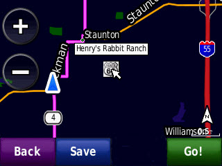
Route 66 Attractions with Ready2Go Tours screen shotBut the Ready2Go Tour doesn’t just ignore alternate alignments. For one thing, it is built on top of that extensive database of Route 66 attractions and not all those attractions are right along the tour path. At any time a traveler can push “Where To?” to see what attractions are near by. Click here for a screen shot of the list of attractions near the point where the alignments separate south of Staunton. Some, including Henry’s Rabbit Ranch, are not on the tour route. Selecting an attraction accesses an overview of a drive there. A description is also available and the location of the attraction can be seen on a map as pictured above. Note the tour route in magenta and the blue triangle showing current position. Even without those maps and books, a traveler can visit an “off route” attraction then head back to continue the tour.
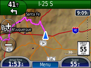
Route 66 Attractions with Ready2Go Tours screen shotOne alternate alignment actually appears in the product today. The pre-1937 alignment that passed through Santa Fe, New Mexico, can be selected and followed just like the main tour route through the state. In the future, other major alternates, such as the one between Staunton and Springfield, will be added.

Without detailing every turn, I can say that the Ready2Go Tour seemed to follow its chosen alignment quite well. In general, after we reached Springfield and started down the 1926-1930 route, the voice in the box and the car in front of me were in agreement. Exceptions were when the caravan occasionally headed off on some obscure and possibly dead-ended section. But then the caravan did have books, maps, and experts and a readiness to get lost explore. Both the path and the location of attractions presented by the Ready2Go tour seemed right. I’m happy to report, as I’m sure some are wondering, that it nailed the Nilwood turkey tracks perfectly.

I suppose it’s fairly obvious that this is a good fit for someone heading off on all or part of Route 66 for the first time. Then what? As a solo traveler, I basically require voice-in-a-box guidance on a road trip and getting it usually involves plenty of pre-trip plotting. I’m not throwing away any books and I’ll still be plotting routes including some involving Route 66 but there’s a big chunk of that that River Pilot Tours has done for me. Having the big catalog of attractions always at my fingertips is pretty cool, too.

I said I feared that, even after finding the company owner extremely helpful and likable, I wouldn’t like the product. I think my biggest fear was that it would be fragile or that Garmin would mishandle the routing. But Route 66 Attractions with Ready2Go Tours seems to do exactly as it claims and I do like it. Shouldn’t have worried.

UPDATE 05-SEP-2012: I recently completed an end-to-end east-to-west drive of Historic Route 66 using Route 66 Attractions with Ready2Go Tours as my primary guide. I deviated from the suggested route on several occasions but the deviations were to visit some attraction or follow some alignment of which I was aware and not because of a Ready2Go error. As near as I could tell, the suggested route always followed some Route 66 alignment even though it wasn’t always the one I wanted to follow. In many cases, Ready2Go helped me find those off route attractions or other alignments.

As I explained in the original review, the product contains information on lots of Route 66 attractions and can be used to find those attractions even when they are not on the tour route. I was well aware of that but was a little surprised to find that some alternate alignments showed up as well. They did not appear as a route with turn-by-turn directions but the end points appeared as attractions which made finding them easy. Prime examples are the two “sidewalk highway” segments south of Miami, Oklahoma. The segments themselves are perhaps a bit rough to be included in the main tour but all four points where one of them intersects the main tour were marked so they could be located and driven if desired.

My deviations were due to personal preferences that came from previous trips, reading, and talking with other travelers. I’ve little doubt that just following the main line Ready2Go tour would provide a full and satisfying Route 66 adventure for the first-timer and I’ve just proven that it provides a pretty good foundation for the more seasoned roadies (i.e., old farts) among us.

Music Review
No Agenda
Ryan Kralik

No Agenda CD coverI was pretty much prepared to not like this. I only became aware of Ryan Kralik when he recorded a cover of Neil Young’s “Ohio” with Josh Hisle but I’ve certainly heard of him a lot since then. Actually, heard from him a lot would be more accurate. In order to download that “Ohio cover, I signed on to his mailing list and that led to becoming Facebook friends. Down these two funnels, Kralik has poured a steady stream of promotional messages. The first were about the “Ohio cover, then they were about this album, and now they are about an in process tour. I’ve no particular problem with guerrilla marketing of this sort. It may lack the punch of a full page ad in Rolling Stone but, for cash strapped artists, it beats a blank and can be fairly effective. But the primary goal of Kralik’s messages seemed to be connecting his name with the better known musicians who had helped with the recordings. The basic idea is no doubt good but when that seemed to be about the only thing Kralik had to tout and I’d heard it too many times, it became off-putting. There seemed to be far too much grasping at coattails involved. I became irked rather than piqued.

So I kind of hoped to just ignore the album but knew that wouldn’t be easy. In an idle moment a few days after a streaming preview became available, I gave it a listen. It didn’t suck. It sufficiently didn’t suck that I ordered it under some special edition half price offer. That was in late November. It arrived sometime between January 27 and February 6. I was out of town so can’t really nail down the delivery date but I clearly had a couple of months for negative thoughts to grow. This was not the result of simple laziness. The delay was caused by production problems but it was still a delay and it did nothing to endear Mr. Kralik to me. Some of that guerrilla marketing talked about the packaging so I kind of knew what to expect. The CD itself is made to look like a vinyl record complete with (printed non-spiraling) grooves. It is inside a standard cardboard CD sized sleeve. That sleeve is in one side of what looks like a folding double LP jacket (for 7 inch LPs) along with some stickers, tickets, and such. The other side of the jacket holds a very nice booklet with lyrics, pictures, personnel, and most of the other things you want to know about a CD but aren’t always told. That booklet, all by itself, counterbalanced a whole bunch of the negativity I’d developed. The remainer was knocked off by the music.

Those names that Kralik dropped with wild abandon early on are all here. Dave Krusen (Pearl Jam) is on three tracks. Rick Rosas (Neil Young, Joe Walsh) is on two. Michael G Ronstadt appears three times and Josh Hisle once. Josh and Michael I know from their solo stuff along with their work with Lost in Holland and Ronstadt Generations. Some of these guys and a couple of others get the occasional music credit but the lyrics are all Kralik’s. So are the vocals.

The music begins and ends with ukulele tunes. Another resembles something the Ramones might have done. That’s quite a range though No Agenda does not hit much of the space in between. The two uke songs and another tune, “Me and You”, which might actually be a love song, are kind of slow and kind of quiet. The remainder are all driving rockers. Kralik is no opera singer but he doesn’t try to be. He doesn’t push his range in delivering the topical and witty words he has written and it sounds right. “The Egypt Riot”, that Ramonish tune I mentioned and which is my favorite on the CD, could almost be too topical. The big time protests in Egypt came and went while No Agenda was being birthed but songs that capture a moment, like the aforementioned “Ohio”, are often good things. Maybe “The Egypt Riot” does that. I’m not sure.

When Rosas and Krusen aren’t around, Keith Lowe and Jeff Strainer do admirable work on bass and drums and Pete Jive contributes some nice guitar to those two ukulele pieces. Kralik’s guitar can be heard on almost every track and it’s solid but it is James Holsapple who adds the bright work here. I particularly liked what he does on “The Setting Sun” where he deservedly gets co-writer credit.

I’ve named three songs and there are five more. Yep, eight songs, totaling about thirty-two minutes of music. Maybe that’s not unusual today. I really don’t know. I certainly wouldn’t mind if there was more music here and that would not be the case if the music sucked. It doesn’t.

Check it out here.

Book Review
Oklahoma Route 66
Jim Ross

Oklahoma Route 66 coverI like this book so much that I have three copies of it. Well, maybe not three exactly but more than two. I got my first in 2007 in anticipation of an Oklahoma trip. It didn’t take me long to discover that the copy was flawed and it didn’t take much longer for a replacement to be provided. A printing error had caused many pages of that first copy to be omitted, duplicated, or otherwise jumbled. The replacement, with all pages present and in the right place, was quite an improvement. This second edition is also an improvement though not that drastic. With it’s accidental mishmash of pages, that first copy was essentially unusable. Every other copy of first edition Oklahoma Route 66 was eminently usable. The second edition is even more so.

The book’s organization is essentially unchanged from the first edition, Michael Wallis’ “Introduction” has been replaced by a “Foreword” written by Jerry McClannahan and Ross’ own lead in, which was once called a “Foreword”, is now a “Preface”. But, as Shakespeare might say, an introduction by any other name would still introduce and both Jerry and Jim do just that. Jerry helps to establish Jim’s credentials in a fun to read couple of pages then Jim fills in a little of the space between the two editions. He also explains, just as he did in the first edition, that this is literally a book about the road. Roadside attractions and Route 66 personalities are not entirely ignored but they are secondary. The route itself is the book’s focus.

Where did it go and when did it go there?

Jim Ross is really good at digging out answers to that question as well as communicating them. It is in communicating the route’s changing course that this edition’s biggest single change, color, really pays off. As Ross says himself in that preface, it is “…nice for the photos, but especially helpful with the maps.” Photos and other images are used extensively throughout the book. Some are newly acquired and in color though many are the same ones that appeared in the previous edition but now printed in color where applicable.

I don’t believe that any maps have been added to this edition though many have been revised to reflect changes on the ground or better understanding of past alignments. There are, of course, quite a few “past alignments” to be dealt with. In the earlier edition, dealing with them meant annotations on black and white maps. It worked. The information was certainly there and it could be extracted with a little reading and thought but it is so much easier when a green line marks the original alignment and other colors mark later alignments.

The maps appear in a section titled “The Tour”. It follows those introductions and short sections on the road’s history and construction and an explanation of the maps. “The Tour” is the heart of the book and it does indeed serve as a guide for an east to west tour of Historic Route 66 all the way through Oklahoma. Driving instructions are for what Ross calls a “through” route. This means that dead-ended abandoned stretches are not included. They are shown on the maps, however, and described in the text so someone set on finding every possible inch of Sixty-Six can do so. The text also describes the communities along the route and some of the landmarks in between and it usually provides some interesting history on those communities and landmarks including some that no longer exist. The tour is well illustrated with photos and other images and they are not just filler. Ross is as well known as a photographer as he is an historian. His own current photos are mixed with some by others and quite a few historic ones from various archives. “The Tour” of Oklahoma Route 66, even in an armchair, is far from boring.

Oklahoma Route 66 second edition, Jim Ross, Ghost Town Press, October 2011, paperback, 9 x 5.9 inches, 220 pages, ISBN 978-0967748177
Available through Amazon.

Book Review
Wabash 1791
John F Winkler

Wabash 1791: St Clair's DefeatBack in November, I stopped at Fort Recovery specifically to pick up a copy of Wabash 1791: St Clair’s Defeat and to hear the author speak. There’s a blog entry about that visit here. John Winkler began his talk that day by briefly describing the circumstances that preceded the battle then, while frequently pointing to a projected map of the battlefield, he stepped through November 4, 1791, by locating key figures and events in space and time. He spoke from memory and it was obvious he knew his stuff. The knowledge he demonstrated in that talk fills the pages of Wabash 1791. In fact, the book could be considered a hard copy version of that talk — with a few thousand-fold increase in detail.

Winkler begins the book, as he did that presentation, by talking of things that led to the battle only here he is not quite so brief. The world at the end of the eighteenth century can be pretty tough for modern-day readers to imagine. When the Battle of the Wabash took place, the United States constitution was barely three years old and our very first president was only halfway through his first term. The Ohio River was the nation’s border. England was still very much a military presence in North America and would officially be at war with the US in another twenty years. In 1791, there were plenty who thought England just might be picking up the pieces of her old colonies once the US collapsed.

After Winkler describes what he calls “The Strategic Situation”, he moves on to describe the opposing forces. The leaders of the two armies were certainly different but all were among the best of their time. St Clair, Butler, and Darke are just a few of the proven officers leading the Americans. On the Indian side, an equally qualified group of leaders surrounded chiefs such as Little Turtle, Blue Jacket, and Buckongahelas and the hated renegade Simon Girty. Also present were some out-of-uniform British officers. At the level of individual combatants, however, different meant unequal.

Recruiting had not gone well and continuing supply problems made it worse. Delays in supplies resulted in expiring enlistments and lack of supplies hampered training. In a sad “For want of a nail the shoe was lost…” style example, a shortage of paper led to a shortage of musket cartridges for training and target practice. As hard as it is to believe, some new recruits marched out of Camp Washington without ever having fired their guns. By contrast, fighting was part of every Indian’s life. Winkler quotes an officer who wrote, “…war is their principal study, in this they have arrived at considerable perfection.”

I hesitate to use the word “scholarly” but it really is appropriate for portions of the book. In particular, some of this early background information reads like a textbook and can be rather dry going. But there’s lots of good information being conveyed and the payoff occurs when the battle begins. Winkler can report the action without the need to repeatedly explain why one side did this and the other that. And report the action he does and it is brutal. Though the two armies were roughly equal in size, approximately 1700 soldiers and militia versus 1400 Indians, most of the experience and all of the surprise was with the Indians.

Two types of illustrations augment Winkler’s battle descriptions. Color-coded diagrams show three stages of the battle and artist Peter Dennis has produced three “snapshots” to help visualize the scene. The one used for the cover shows Captain Henry Carberry shouting at the demoralized soldiers to charge the encircling Indians simply in order to escape. Numerous photographs and drawings illustrate other sections of the book.

More US soldiers died that day than in any battle prior to the Civil War. This battle was the greatest victory American Indians ever achieved over US forces. The loss nearly eliminated all United States military capabilities and had the potential for destroying the young nation. In fact, a proposed investigation into supply chain corruption was abandoned to avoid that very risk. With the passage of time, this clearly significant battle has been largely forgotten by non-historians. How much success Winkler’s book has in reviving the memory is yet to be seen but it seems to contain all of the details needed for filling in the blanks.

Wabash 1791: St Clair’s Defeat, John F Winkler, Osprey Publishing, November 2011, paperback, 9.6 x 7.1 inches, 96 pages, ISBN 978-1849086769
Available through Amazon.


I’ve seen other accounts of St Clair’s Defeat. Allen Eckert’s fairly short one in That Dark and Bloody River is a pretty easy read. Eckert writes in the style of a novel with the factual base of a text book. In my youth, as I was first learning of the battle that occurred just about fifteen miles from where I grew up, I formed the impression that St Clair was a bumbling idiot and was almost single-handedly responsible for the disaster. As I learned more about the supply and equipment problems, my view softened. Eckert blames St Clair for not aborting the campaign in light of the huge recruiting and supply issues but little else. Winkler hardly blames him even for that. That could just be the result of Winkler’s even-handed reporting where he presents facts and holds back opinions.

As I read Wabash 1791 with the internet at my fingertips, I learned of a 1896 Harper’s Magazine article on the subject written by Theodore Roosevelt. This was just over a hundred years after the battle. A slightly edited version was included in volume 5 of Roosevelt’s Winning of the West published in 1905. Roosevelt doesn’t think much of St Clair and describes him as possessing “none of the qualities of leadership save courage.” Perhaps he was a bumbling idiot after all. ‘Tis a puzzlement.


Thumbnails of scans of the Roosevelt article appear in the archives section of the Harper’s website. Accessing full-sized readable copies requires a subscription. However, there is another section of the website, apparently sponsored by Balvenie Scotch whiskey, which contains articles written by folks such as Lewis Carroll, Mark Twain, and… Theodore Roosevelt. Maybe they’re all Balvenie drinkers. The 1896 Roosevelt article is available there. A far-from-full bottle of The Balvenie sits in my liquor cabinet and I poured myself a wee dram to drink a toast in thanks for the article. You can read the article here but you’ll have to supply your own whiskey.

Book Review
The Long Ride
Charles Woodruff

The Long RideI suppose non-roadies think we’re all alike. Normal people go to places and they do it in the most efficient manner possible. To them, folks who mutter stuff like “The journey is the destination” more than once every decade or so, just aren’t normal and should probably be avoided. They’re right, of course, but there is variety in our abnormalities.

Charles B. Woodruff, author of The Long Ride: 23 states in 22 days in a 1951 Hudson qualifies as a roadie. He enjoys riding more than arriving and two lanes more that four and he knows about the Lincoln Highway and Route 66. He’d probably even enjoy following the Lincoln or Sixty-Six end to end but that’s not what floats his boat the highest. Following Route 66 in a rented Mustang wouldn’t interest him nearly as much as following some lesser road in a Hudson; Preferably the 1951 Super 6 he’s owned for nearly forty years.

The Long Ride recounts Woodruff’s drive from Schenectady, New York, to Spokane, Washington, and back again in that Hudson. It wasn’t his first road trip in the car or even his first long trip. By the time he pulled out of Schenectady and headed to the 2010 National Hudson Meet in Spokane, he and the car had already visited 43 of the contiguous United States together. By the time he returned, it was all 48.

The book is “Published by the author” so it’s not quite as polished as the latest Random House offering but neither is it particularly crude. Woodruff is a librarian in real life so he knows his way around books. I saw a few errors that a high priced copy editor might have squelched but there’s no guarantee of that. This is a very readable account of a quite interesting journey.

There are pictures, too, including a few black and white ones of his parents and a younger self. But most are in color and taken during the Long Ride with a digital camera purchased just days before departure to replace a 35mm stolen in November. Somewhere along the way, Woodruff admits that the thief may have actually done him a favor by forcing this bit of modernization on him. In the photos, the car is the star. It isn’t in every picture but it is in most. That is as it should be. The Hudson is shown at state lines and in front of houses. There’s a nice shot, taken from the board-walk fronting a Montana saloon, of it waiting patiently in an unpaved street. That saloon struck all the right chords with Woodruff and looked rather inviting to me, too. The cover shows the old car parked beside the Bonneville salt flats with a glorious day climbing over the horizon behind it.

Woodruff talks about the country he passes through and the gathering of Hudsons that is the reason, or more accurately the excuse, for the trip. He describes the friends that share portions of the Long Ride and places with family connections where he stops along the way. He talks a lot about the car and its history. What he doesn’t talk about is car trouble. I hope I’m not ruining too much suspense when I reveal that, except for a few instances of vapor lock, the fifty-nine year old performs admirably. Oil and brake fluid had to be replenished now and then and, more than once, Woodruff shares his concerns about the temperature gauge climbing when traffic or construction slowed forward progress and reduced airflow.

The trip is, in fact, so trouble free that I’ve almost forgotten just how big an undertaking it was until the epilogue reminds me. Woodruff had very few preparations planned for the car before taking off and real life circumstances prevented him from accomplishing even all of those. As I began the book and saw the old Hudson pulled almost directly from storage and pointed westward, I felt that a few hours stranded by the road were probably inevitable and a drive ending malfunction only slightly less likely. By the time the car and its driver cross back into New York, those concerns were pretty far in the background. They are recalled , however, when Woodruff talks of doing it “…on my terms or not at all.” Of not doing it “…in a modern car or even a Hudson that was in tiptop condition…” or “…in a caravan…”. Woodruff is writing about himself and his plans for the drive when, early in the book, he says “Crazy? Maybe.”

So what?

The Long Ride: 23 States in 22 Days in a 1951 Hudson, Charles B. Woodruff, Published by author, 2011, 9 x 6 inches, paperback, 191 pages.
Available from author:
Charles B. Woodruff
DoDDS-K, Unit 15549
Box 141
APO AP 96205
cbwoodruff@hotmail.com
Price $19

Book Review
Route 66 Sightings
Graham, McClanahan, & Ross

Route 66 Sightings coverI expected to be impressed by the images in Route 66 Sightings. They come from three of the best photographers ever to point a camera at Route 66. I didn’t expect to be educated though I now realize that I should have. Those three photographers, Shellee Graham, Jim Ross, and Jerry McClanahan, are also three of the most competent of Route 66 historians.

The first book I reviewed on this blog was a photographer-writer collaboration. That’s a fairly common arrangement. It’s not because the writer can’t take a decent photograph or because the photographer is illiterate or knows nothing about the subject.  It’s because one person typically produces better images while the other is the better word smith and/or more knowledgeable. The three people behind …Sightings are all quite adept at recording, remembering, and ‘riting.

Unlike many books connected with a road, the organization here is not geographic. No east to west or north to south. Instead, the photos are divided into categories. Roadside attractions and businesses that have completely vanished are pictured in a gallery (Yeah, it’s a lot like a chapter.) called “Gone”. Some that can still be visited, but just barely, appear in the “Used to Be” gallery. “Against the Odds” covers the rare business or attraction that continues being what it’s always been and “Rescued” covers those that live on by being something different. Roadside attractions with a recent beginning make up “New Kids on the Block”.

“Gone” is the first gallery and I believe it is my favorite. Of course, nothing in the gallery exists today. With very few exceptions, they were gone before I started paying attention to Route 66 in any meaningful way just shy of the turn of the century. So I get a glimpse of things that I’ll never see in the real world and that fact, no doubt, has a lot to do with the chapter being my favorite. Some of the subjects were still operating (Shawford Motel, Club cafe) or at least intact (Coral Court Motel) when photographed. Others (Conway Motor Court, Querino Canyon Trading Post) would be candidates for the “Used to Be” gallery if time hadn’t since obliterated them completely. I have to single out McClanahan’s picture of the Querino Canyon Trading Post, with the buckled building frozen in mid collapse, as a personal favorite.

By being first, the “Gone” gallery introduces the format for the book’s layout. It isn’t particularly rigid so maybe style is a better word than format. With but a few exceptions(3, I think) each spread (both verso and recto pages, and yes, I did have to look that up) is a set. There is one large photograph and two or three smaller ones. All are of varying sizes. They may or may not all be by the same photographer and may be of the same subject or merely related subjects. The accompanying text is written by the person who produced the set’s large image. It looks good and works well.

And the “Gone” gallery does one more thing. It bolsters the credentials of the authors. I’ll confess to not knowing exactly how long each of these writer-photographers has been cruising Route 66. I believe McClanahan has been doing it most of his life and I suspect that’s true, or close to it, for Graham and Ross, as well. Regardless of what the year counts are, the pictures in “Gone” show that these three were looking seriously at the road and the world around it long before most of us even got off of the expressway. The accompanying text is a combination of personal memories, learned history, and an occasional thimble full of roadside philosophy. You step out of the gallery feeling that, if they know that much about stuff you’ve never even heard of, they’re certainly qualified to write about anything the other galleries might hold.

“Used to Be” is filled with thought-provoking pictures of abandoned and deteriorating buildings. Two photos in particular grabbed my attention. Both are by Jim Ross as are the majority of photos in this section. The first is of the Painted Desert Trading Post. I’ve never been there but I’ve seen plenty of pictures. Most are close-ups that show the building and its hand painted signs. Ross has captured the view from some distance so that the actual trading post, on a fading gravel road surrounded by lots of nothing, takes up a very small portion of the photo. He tells us that this was an “opportunity to more fully portray the desolation of the site”. It does indeed.

The other “Used to Be” photo that tugged at my eye is of a place where I have been. I’ve visited John’s Modern cabins a couple of times and I’ve seen scads of photos. Ross sets his photo apart from most by filling the frame with the green of the shingles and the red and yellow of the faded sign backed by green leaves. The condition and, yes, the desolation, of John’s Modern Cabins may be more accurately shown in Jim’s wider and grayer and more typical shot on the opposite page but I like the green.

Because they are currently active, the subjects of “Against the Odds”, “Rescued”, and “New Kids on the Block” are likely more familiar to fans of the road than even those of “Used to Be”. Not only do they show up in trip reports and vacation albums, many are actively promoted and advertised. Of course, the trio behind Route 66 Sightings does not do normal even here. Shellee Graham puts owner Fran Houser’s autograph covered truck in the foreground of a Midpoint Cafe photo, Jerry McClanahan captures a restored 1956 Greyhound in front of the Munger Moss in 2010, Jim Ross shows us the Hackberry General Store with snow on the ground, and there are plenty more.

There is, in fact, a whole gallery I’ve not even spoken of. It shares its name with the book itself and is called simply “Sightings”. It’s potpourri; Really good potpourri. It contains photos that the authors liked well enough to include despite them not fitting in any of the planned galleries. How’s that for an endorsement?

The quality of the contents is pretty much matched by the quality of the book itself. The slick heavy pages reproduce the photos wonderfully. There’s little doubt that a picture’s colors appear just as the photographer intended even for the book’s handful of black and white images. It’s a beauty… and smart, too.

Route 66 Sightings, Jerry McClanahan – Jim Ross – Shellee Graham, Ghost Town Press, October 2011, 12.2 x 9.3 inches, 200 pages, ISBN 978-0967748184
Available through Amazon.

Book Review
Border to Border on US Route 89
James Cowlin

US-89-Photography-Guide-CoverWhen I first glanced at the title of James Cowlin’s latest ebook, I’m pretty sure I expected it to contain advice on exposure and filters and other photographic folderol. But a more thoughtful reading of the carefully constructed title yielded a different impression. Just as the title says, Border to Border on US Route 89; A photographer’s guide to America’s most scenic highway is not a guide to photography. It’s a guide to a highway.

It was written by a very accomplished photographer and other photographers, even some as good as Cowlin himself, can benefit from it. But, at its heart, the book is simply a guide to Cowlin’s beloved US 89 written — and illustrated — from a photographer’s point of view.

The book is organized around thirty photos taken in the spring of 2010 as the Cowlinses (Jim and wife Barbara) traveled the highway from Mexico to Canada. Each beautiful photograph is accompanied by a few lines of text which typically tell something about the subject as well as something about the photo. But that something about the photo is not F stops and focal lengths. It’s generally just Jim explaining what he saw and tried to capture.

The photos appear, each on its own page, in south to north sequence. Cowlin sees three geographic regions along the route and a couple of pages of description precede the photos from each region. These pages provide a little background, give some idea of what might be seen there, from the 58 kinds of reptiles and amphibians in southern Arizona to the glaciers at the Canadian border, and identify some favorite photo ops.

The book does not contain detailed instructions for driving the route or for duplicating the wonderful pictures. It does contain an excellent overview of the road that Cowlin calls “America’s most scenic Highway”. He lets slip the real purpose of the book in the forward when he says “I do hope that this guide will inspire you to take a road trip on US Route 89.” The book definitely contains a lot of inspiration.

James Cowlin is the founder of US Route 89 Appreciation Society. Border to Border on US Route 89; A photographer’s guide to America’s most scenic highway can be purchased here. A Road Trip Map Book is available here.


Deciding that book reviews were a good fit for this blog instantly put me way behind. If I posted them on Sundays when there was nothing more pressing it might take me months just to squeeze out the half-dozen or so already on the list. To keep that from happening, I’m going to post book reviews on Wednesdays for the next few weeks and leave Sundays for whatever.

Book Review
Ghost Towns of Route 66
Jim Hinckley

Last week’s visit to Fort Recovery was triggered by a book. That book, a new one on the 1791 Battle of the Wabash, was available (pre-release) and its author, in addition to autographing copies, gave a presentation on the battle. As I wrote the blog entry about the visit, I was simultaneously struck by the idea of reviewing the book and the realization that book reviews might make good subjects for blog entries. I’ve recently picked up a few new books including some by people I know and to whom I’ve promised some feedback. Reviews, it seemed to me, would be a good way to feed the blog and focus the feedback. So here is the first book review entry. I promise there will be more.

Ghost Towns of Route 66The subject of this review is a book I picked up from the author, Jim Hinckley, when I passed through Kingman, Arizona, in June. Ghost Towns of Route 66, is the second Hinckley product I’ve read. The first was Route 66 Backroadswhere I was at least as impressed with the photography as with the writing. That is true of the newer book as well. …Backroads used photos from Kerrick James and Rick & Nora Bowers along with some from outside sources. James is the only photographer listed on the cover of Ghost Towns… although there are a few by others including Hinckley. My praise for the photos is not intended to diminish Hinckley’s writing but to recognize some wonderful images and acknowledge a huge reason that these books get a second look when spotted on a store shelf or counter.

Ghost towns is a subject where photos and words can truly complement each other. By definition, a ghost town is a place that was once thriving but is no longer. When you visit a ghost town, you look at what remains and try to imagine what once was. James’ pictures let you see what remains and Hinckley’s words help you imagine what was there once upon a time.

Hinkley’s words are the result of some serious research. The man definitely does his home work. Facts about a town’s beginning are usually given and the events and circumstances leading to its rise and fall are discussed. Some of the falls are complete while others are far from it.

A few towns on Sixty-Six do match the far west ghost town image of complete  desolation with nothing moving but tumble weeds. Those that do, like Allanreed in Texas, Endee in New Mexico, and Glen Rio on the state line between them, tend to be a bit to the west themselves. Other towns that Hinckley has included, such as Galena in Kansas and Afton in Oklahoma, ain’t dead yet.

In fact, Galena and Afton are current must-stops on any Route 66 trip through the area. In Galena, 4 Women on the Route has become a major roadside attraction in just a few years and in Afton, Laurel Kane’s Afton Station, established a bit ahead of 4 Women…, is a true Route 66 icon. But Hinckley isn’t to be faulted for including these towns. Both are mere shadows of their boom time selves. The decline has currently ceased and maybe even reversed but there was sure a lot of it and there is no guarantee that it isn’t just paused.

This isn’t the first book one should acquire when planning a drive down Historic Route 66. In my opinion, that spot belongs to Jerry McClanahan’s EZ 66 Guide and there are other route related books offering a broader view of the road and the attractions at its side. But, if you are attracted to clusters of dilapidated buildings and often wonder what a wide spot in the road used to be, Ghost Towns of Route 66 could be just the book you want. You’ll get lots of history and some great photos of many un- and under-populated
settlements along the historic highway.

Ghost Towns of Route 66, Jim Hinckley and Kerrick James, Voyageur Press, June 2011, 10.25 x 8.75 inches, 160 pages, ISBN 978-0760338438
Available through Amazon.


Viva la Mush or rebellion in the heartland. I like fried mush. It reminds me of my childhood. The fact that Bob Evans restaurants served this breakfast staple accounted for many — perhaps even most — of my visits there. Last month, when my local Bob Evans informed me that mush was no longer available, I was heartbroken. When this came up in a conversation with my sister, she told me that, although it was no longer on the menu, fried mush could still be had at the Bob Evans in Greenville, Ohio, if you asked. I stopped in to make sure she wasn’t just teasing me and found that, not only was it available, it had been returned to the menu. I told the cashier how I had been forced to come there because my own Bob Evans had dropped my favorite and she told me they had tried that, too, “but it didn’t go over very well.” After a week or two mush was returned and it reappeared on the menu at the next printing. Viva la mush and viva the small town restaurant manager who keeps her customers happy in spite of corporate directives.