Book Review
20 in ’21 and the YT Too
Denny Gibson

Missed it by that much. I had this really great idea for a book title, and even figured out the story that would fit it. I would drive one way across the country on the Yellowstone Trail and the other way on US 20. I would do this in the year 2020, and the resulting travelogue would be perfectly described by that catchy title: 20 in ’20 and the YT Too. But COVID-19 played havoc with 2020 travel plans and the wonderful title’s “best if used by” date came and went. I made the planned trip a year later and adjusted the title appropriately. It’s admittedly not quite the same but it’s not horrible. Is it? Well?

As for the trip, it certainly wasn’t horrible. It was fantastic. And the resulting travelogue isn’t horrible either. Maybe not fantastic but definitely not horrible. I think calling it pretty good is legit. It’s got pictures.

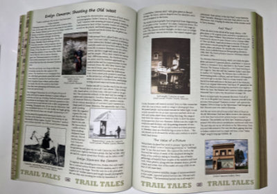
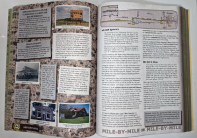
It has more pictures than any previous Denny Gibson travelogue. It would also have the most pages if you took Granny’s letters out of Tracing a T to Tampa. I’ve been saying it has nearly 200 photos. I believe the actual count is 192 and “nearly 200” sounds much more impressive than “over 190”.

Like all the previous travelogues, the pictures are black and white. I started this project intending to use Amazon’s new improved color options. I even had a proof copy printed in premium color to see how it looked. It looked good. I asked myself if I thought other people would pay $30 or more for the book and answered, “Probably not”. Then I asked myself if I would pay $30 or more for the book and again answered, “Probably not”. So I backed away from the idea of a full-color glossy-paged thing of beauty and again embraced the idea of a gray-scale matte-paged thing of practicality. However, just as with the others, there is a Kindle version with color pictures. Electronic color is free.

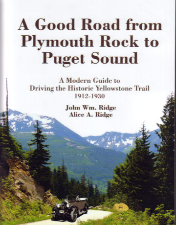
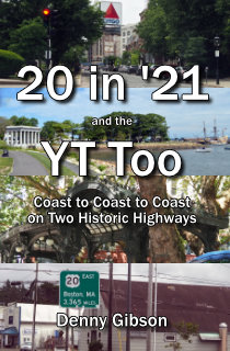
The subtitle is a bit misleading. The documented trip doesn’t really start on a coast. It starts in Ohio, goes to the Atlantic, then the Pacific, then back to Ohio. The book sometimes refers to this as C2C2C2C (center to coast to coast to center) but that requires way too much explanation to work as a subtitle. The pictures on the front cover do a better job of describing this sequence than the subtitle does. From top to bottom they show a sign in Boston, Plymouth Rock, Pioneer Square, and a sign in Newport. These represent the termini of the pair of historic highways in the sequence they were reached. First is US 20’s east end then the Yellowstone Trail’s east end. The Yellowstone Trail’s west end is next followed by the west end of US 20. The book covers a whole lot of traveling before that first terminus and after the last one.

In summary, the book has a cool (but not as cool as it could have been) title, tells about crossing the USA twice on historic highways, has lots of B&W (though color was considered) pictures, and has an almost but not quite true subtitle. What’s not to like?

20 in ’21 and the YT Too, Denny Gibson, Trip Mouse Publishing, 2022, paperback, 9 x 6 inches, 189 pages, ISBN 979-8422405411.

Signed copies available soon through eBay. Unsigned copies available through Amazon.

Reader reviews at Amazon and Goodreads are appreciated and helpful and can be submitted regardless of where you purchased the book. All Trip Mouse books are described here.

Book Review
A Good Road from Plymouth Rock to Puget Sound
John & Alice Ridge

I’m going the get the full disclosure stuff out of the way right up front. In July of 2020, as I was getting serious in planning my own drive on the Yellowstone Trail, the Ridges gave me access to an online preliminary version of the Washington chapter of this book. Then, when I actually made that drive and stopped to visit them in Wisconsin, they supplied me with their most recent markups for all of the states I had yet to cover. But, even with those extraordinary “sneak peeks”, holding the finished product in my hands revealed some wonderful surprises.

One can be seen in the picture at left. It is not, as one might reasonably guess, an image of exposed strata at a geological dig somewhere along the Trail. It is a shot of the book’s unusually colorful edge. The book’s subtitle is “A Modern Guide to Driving the Historic Yellowstone Trail 1912-1930”, and a majority of its pages are dedicated to providing that guidance through maps and mile-by-mile descriptions of the route and things beside it. There is a brown-edged guide section for each of the thirteen states through which the Yellowstone Trail passed. Those guide sections also contain what the authors call “History Bits” on a gravel background that appears mottled at the edges. These pages contain old newspaper articles, driving notes, and other items. Preceding each guide section is a yellow-edged introduction to the state. Green-edged pages contain history and other information that does not apply to a single state. Although I have no field experience with this color coding, it strikes me as something that cannot help but make it quicker to access a specific subject or map.

All those colors also serve to indicate that the book goes well beyond its subtitle. I wasn’t totally oblivious to that in my earlier looks but with those, I had been almost entirely concerned with where to go. With relaxed navigational needs, those yellow and green pages got a lot more attention and I found them quite interesting. They make good reading even if you have no intention of ever driving a single mile of Yellowstone Trail. In fact, not every item on them is directly tied to the YT. Plenty of interesting information and stories about the early days of auto travel appears on these pages and on some of those gravel pages, too.

As can be seen, there are tons of photos in the book. They are in color on non-gloss paper. Most are rather small but all are clear and large enough to serve their purpose. Sure, it might be nice to see some of these images as 8 by 10 glossies but this is a book to use not to lay on a coffee table. The paper choice helps keep the book’s price reasonable and the image size allows more to be included. Good choices, I’d say.

I guess you could say that the gravel and brown pages are the reasons for the book’s existence. They make up that “Modern Guide to Driving the Yellowstone Trail”. It is these pages that I have actually used in the past and I found them accurate and informative. Note that, although “History Bits” and “Mile-By-Mile” pages are interspersed, all “Mile-By-Mile” pages are on the right-hand side and no individual entry is split across pages. This is just one example of the author’s remarkable attention to detail.

The whole book is organized from west to east. The state chapters go from Washington to Massachuttes and mileages given within the chapters are from the state’s western border. An ordering from east to west is probably more common in route guides, but there is certainly nothing magical about it. Primary maps use a uniform four-miles-per-inch scale with each typically covering something around 20-30 miles. They are augmented with higher precision insets when needed, and low-resolution full state maps show where each section map fits within the state.

I have encountered guides that contain turn-by-turn directions and almost nothing more. As a solo traveler, I can appreciate such guides because they make it easy to stay on the route. They also make it easy to miss some point of interest. That does not describe this guide. Using it requires either significant preplanning, a navigator, or frequent review. It may seem like I’m saying that’s a bad thing although I definitely am not. I want good information and I’ll deal with it through preplanning and frequent stops.

The Ridges have been researching the Yellowstone Trail since the mid-1990s. In 2003, they helped form the modern Yellowstone Trail Association and currently serve on its board. They published the 96-page Introducing the Yellowstone Trail in 2000 and probably almost immediately began thinking of this larger guide. That sounds like a long time to research a subject but this subject is over 3,600 miles long and the fact that the records of the original Yellowstone Trail Association were destroyed in 1930 when it ceased operation sure didn’t make it any easier. The Ridges have used that time well and brought together an incredible amount of information on the route’s history as well as its path which they share in a book they call an invitation.

The yellow-edged introduction to South Dakota ends with an invitation to “…enjoy the Trail through the state…”, and there are other invitations in the book as well. The big one, however, is in the very first sentence of the preface. “This book is an invitation to take, by auto or armchair, the Great American Road Trip along the nearly forgotten but historically important Yellowstone Trail.” I invite you to first acquire then accept John and Alice’s invitation. I’m doing it from an armchair right now but I’m ready to do it by auto despite the fact that I did it a few months ago. I’m always ready to repeat a trip, of course, and I always discover things I missed the instant a trip ends. But not like this.

A Good Road from Plymouth Rock to Puget Sound: A Modern Guide to Driving the Historic Yellowstone Trail 1912-1930, John Wm. Ridge and Alice A. Ridge, Yellowstone Trail Publishers (July 2021), 8.5 x 11 inches, 428 pages, ISBN 978-0-9702832-5-2, Available through the Yellowstone Trail Association.