Dayton Remembers

Great 1913 Flood Exhibit at Carillon Historical ParkAt right is a very old light bulb with some very old water inside. The bulb was in a Dayton, Ohio, high school during the 1913 flood, and a microscopic hole allowed water to get inside. The worst natural disaster in Ohio’s history struck on March 25, 1913. On March 23, 2013, a permanent display devoted to the flood opened at Carillon Historical Park. I saw the exhibit for the first time yesterday.

Great 1913 Flood Exhibit at Carillon Historical ParkGreat 1913 Flood Exhibit at Carillon Historical ParkAn existing building was greatly enlarged to house the display though it’s almost impossible to tell the new from the old. The original building was nearly filled by the Rubicon fireless steam engine. The NCR (National Cash Register) owned engine had been a big help in the flood recovery so adding the display to its home seems appropriate.

Great 1913 Flood Exhibit at Carillon Historical ParkGreat 1913 Flood Exhibit at Carillon Historical Park
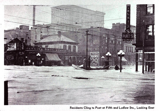
The 1913 flood wasn’t the first for Dayton. The city stands at the convergence of three rivers and a creek so flowing water is ever present. Some actual photographs of the 1866 flood are on display with a larger image of from the 1898 flood as background. There were also major floods in 1828 and 1847. The TV screen with modern style reporting of 1913 weather may look a little corny but it is an effective way of describing the wind, rain, and temperatures that gave rise to the flood.

Great 1913 Flood Exhibit at Carillon Historical ParkGreat 1913 Flood Exhibit at Carillon Historical Park
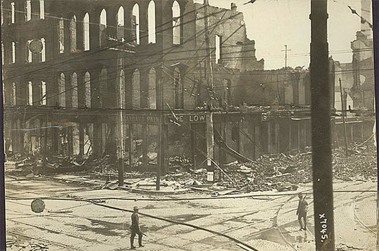
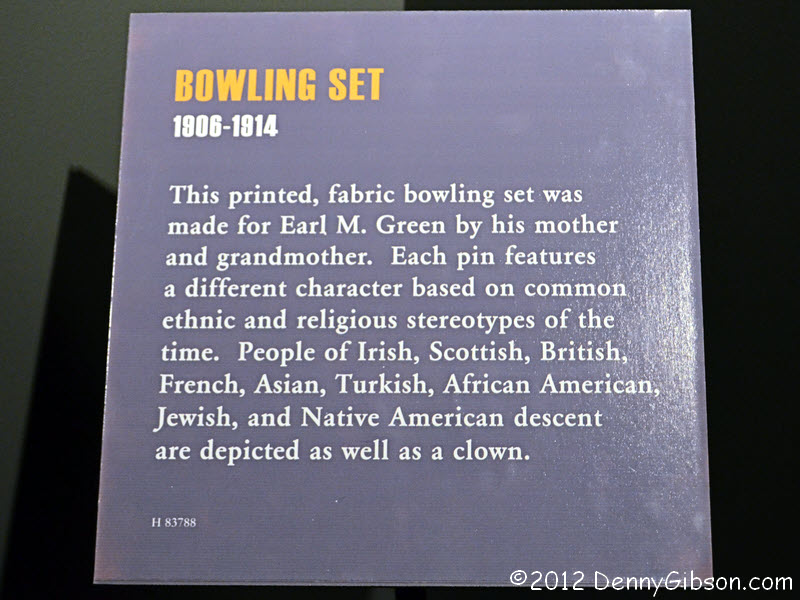
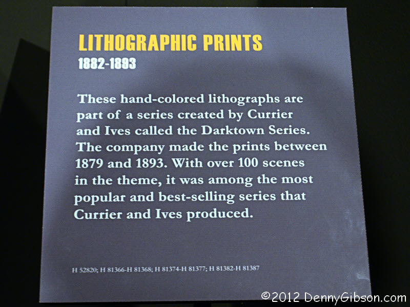
Many personal stories and artifacts help make up the exhibit. Katherine Kennedy Brown’s diary, with a large “The Flood” headlining the record of her experiences, is one. Another is the dress Grace Hall had made for her wedding. Trapped by the flood, Grace was rescued by her fiancé, but the dress was left behind. Read the placard here. The three-dimensional map beyond the dress was made by NCR in 1914 to show the extent of the flood. About fourteen square miles of the city were under water at the flood’s peak.

Great 1913 Flood Exhibit at Carillon Historical Park
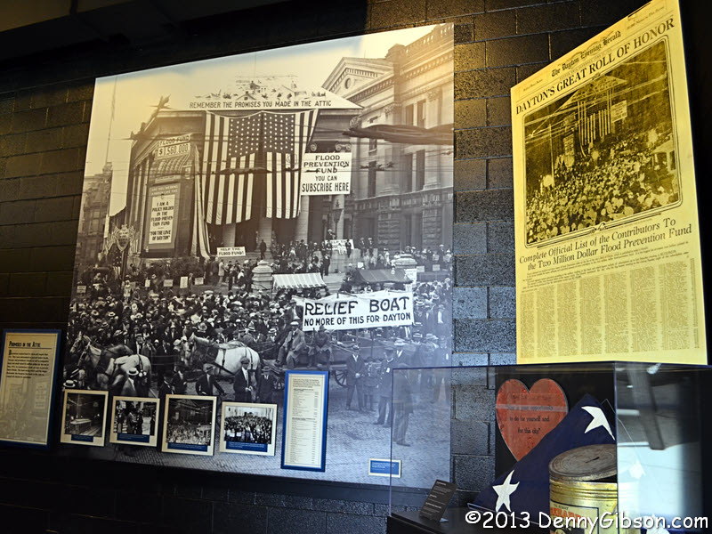
Attics often figure prominently in floods, and they certainly did in this one. “Remember the promises you made in the attic” became something of a rallying cry after the flood. A recreated attic is part of the exhibit, but I didn’t expect much when I stepped into it. The moving light patterns on the solid floor looked about as corny as the derby-wearing weatherman. Maybe so, but it is also just as effective. As I stood in the small space listening to the sounds of water coming from the dark hole that led the lower parts of the house and the creaking of the structure as water pressed against it, that concrete floor became a lot less solid and I had just a tiny sense of what it was like fearing that one of those creaks would change to a crack.

dayflood9The exhibit loops back to the Rubicon, where the story of the birth of the Miami Conservancy District is presented. Many also consider this the birth of modern flood control. Under reminders of those “promises made in the attic”, Daytonians organized and financed a project that has succeeded in keeping Dayton dry to this day. It’s impossible to say just what this hotbed of invention would have become without the flood but it’s fairly easy to guess what it would have become without the MCD.

Carillon Historical ParkCarillon Historical ParkCarillon Historical Park
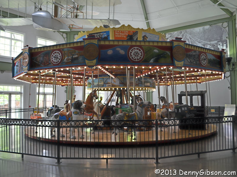
Although the carousel and 4-D theater were here when I visited last year, I didn’t actually see them. The carousel is filled with Dayton icons such as the Wright brothers’ dog and a Huffy bicycle. The animatrons in the theater tell of Dayton history with the help of some seat shaking, wind blowing, and a few dashes of water. The Wright brothers are there along with John Patterson, Charles Kettering, and Colonel Deeds. One of the reasons I’ll be coming back next year is shown in the third picture. Work has just begun on the Carillon Brewing Company, which should open by the end of 2013. The brewery will produce and sell beer using historic tools and methods.

The flood was also the subject of an earlier blog entry, a guest post from HistoricNaturalDisasters.com.

Roadhouse Down

Twenty Mile House demolitionYes, this post is a bit unusual. It’s not a regularly scheduled Sunday post and, although it is a Wednesday, it’s not one of the reviews that are often posted on that day. Nor is it the “real-time” announcement of the start of a road trip. This post concerns the Tuesday destruction of the 191-year-old Twenty Mile House that was also the subject of a post in early 2012.

Twenty Mile House demolitionTwenty Mile House demolitionThe first of the two pictures at left was actually taken Monday evening. In recent days, there had been reports from Friends of 20 Mile House that demolition was imminent. It was reported on Monday that fence was being erected around the building and I drove by at the end of the day fearing that the tear down had already started. It hadn’t. When I read of the arrival of men and equipment on Tuesday morning, I once again headed toward the old landmark expecting to see mayhem in progress. I arrived with the building still intact but it wouldn’t be for long. The picture at the top of the article was taken at 9:05.

Twenty Mile House demolitionTwenty Mile House demolitionThe demolition proceeded rapidly and, despite the unhappy circumstances, it was impossible not to admire the skill of the operator as he worked his machine through the building. The additions of various ages went down first and, even though I certainly knew better, I kept hoping that something would happen to spare the 1822 heart of the building.

Twenty Mile House demolitionTwenty Mile House demolitionTwenty Mile House demolitionThen, in what looked to be as much accidental as planned, a corner fell away when an attached piece of a newer section was removed. One end of the old stagecoach stop was open and my foolish hopes were gone when the workers broke for lunch.

Twenty Mile House demolitionTwenty Mile House demolitionTwenty Mile House demolitionNot long after the men returned, there was an almost ceremonial toppling of one of the old chimneys and destruction of the original section began in earnest.

Twenty Mile House demolitionTwenty Mile House demolitionA second excavator had been brought in and it played the role of buttress as the oldest parts were brought down. At last there was just one section of wall standing with enough height to warrant attention. It was quickly leveled with a simple shove from the second machine.

Twenty Mile House demolitionRoughly six hours had passed since the first blow; A one hour lunch and five hours of destruction. A little less than two hours were spent leveling the section that had stood for a little less than two centuries. A Big Mike’s Gas N Go is to replace the rubble and I’ve no doubt that it will be constructed with the same level of efficiency as that with which the rubble was created. No one I know has any intention of ever spending a cent there but those people weren’t enough to save the Twenty Mile House and they probably won’t be enough to even get Big Mike’s attention in any significant way. There are more than enough people who don’t know or don’t appreciate history to make Mike some money. Big Mike’s will likely be profitable. It will never be loved.

UPDATE: 20-Jan-2018 — A short time ago, I realized that this post was getting many more visits than is to be expected for a five-year-old post. I eventually determined that the source was a link from a discussion of a picture of the Twenty Mile House in a Facebook group (Old Photos of Cincinnati). This is the second of three posts about the historic building. An update to the first one contains a pointer to here, and the third one contains pointers to both of the preceding posts. This one, however, links to neither of the others. I am correcting that now and intend to also update the first post to link to the third. The first post (Twenty Mile’s Last Stand) was posted while the building was still standing, and there was some hope of saving it. The third (Twenty Mile Stand Two Years On) was written two years after the demolition and takes a look at how the new structures relate to what was destroyed.

And Now For Something Completely Different:
A Guest Post on the 1913 Flood

There hasn’t been a lot of requests/offers to do a guest post on this blog but there have been a few. Until the most recent, all were from sites with nothing but contrived and flimsy similarities. They resembled shotgun “link swap” requests more than anything and that, of course, made them easy to ignore. The latest request was different. It came from some fellow Ohioans who call themselves “weekend history buffs”. Their recently launched website looks promising and their initial round of blog posts involves something that’s been on my mind of late. Exactly one hundred years ago today, water started spilling into the streets of Dayton, Ohio, from stressed levees. The flood that followed is the topic of this post from the folks at HistoricNaturalDisasters.com.

ADDENDUM 27-Mar-2022: Obviously my ability to assess new websites leaves much to be desired. HistoricNaturalDisasters may have been promising but it was not delivering. It is now gone and probably has been for quite some time. This nine-year-old guest post may be the only remaining online evidence that it ever existed.


HistoricNaturalDisasters.com Guest Post


The week of March 21st through March 26th marks the 100 year anniversary of one of the greatest natural disasters to ever hit the United States. A series of storms caused flooding and even tornadoes that ravaged the Midwest and parts of New England during this week in 1913 and left hundreds dead and thousands homeless, and caused billions of dollars in damage. One of the cities hit the hardest by the storm’s fury was Dayton, Ohio.

Located along the Great Miami River bend, Dayton had been prone to major flooding events every decade or so since its establishment in 1796. What happened during the storm of 1913, however, was a flood the magnitude of which was unlike anything Dayton had ever seen. Starting on March 21, storms dumped between 8 and 11 inches of rain on the already oversaturated Great Miami River watershed causing all the rivers in the region to swell far beyond their normal banks. At approximately 6 AM on March 25th, the levees holding back the Great Miami River broke and water began to rush into the Dayton streets at speeds approaching 25 miles per hour.

The waters filled the city so rapidly that most of the residents were trapped in their homes and many were quickly forced to take refuge on their roofs as the waters filled the first and second floors of their homes. Many people were faced with essentially camping on their roofs for days on end as they waited for rescue, which proved nearly impossible for relief workers in boats due to the incredibly strong currents of the flood water. The currents were so forceful in fact that many homes and business were literally ripped from their foundations and carried away by the waters, disappearing from the Dayton streets forever.

Downtown Dayton was among the hardest hit areas, with flood waters reaching a high of 20 feet in some spots. Unfortunately, the destruction was just beginning, as fire took hold where the waters receded, fed by natural gas escaping from broken stoves and gas lines and pushed along by strong winds. An entire block of businesses and factories in downtown Dayton was burned down to the water line, with the fire department unable to get men and equipment close enough to help due to the depth of flood waters.

By the end of the flood, March 26th, the damage was widespread. 14 square miles of the Dayton were underwater, and more than 360 people were dead. Some 20,000 homes were completely destroyed, an estimated 65,000 people were left homeless, and all told, the city had suffered close to $100 million ($2 billion in today’s dollars) worth of damage. The cleanup effort took more than a year to complete and Dayton’s economy didn’t make it back to pre-flood levels until more than a decade after the disaster.

1913: Fifth and Ludlow Streets in downtown Dayton during the worst of the flooding

1913: The ruins of the Lowe Brothers Paint Store on the Southeast corner of East Third and Jefferson Street in Dayton

2013: The corner of East Third and Jefferson Streets as it appears today

2013: The corner of East Third and Jefferson Streets as it appears today

1913: Fifth and Ludlow Streets in downtown Dayton during the worst of the flooding

1913: Fifth and Ludlow Streets in downtown Dayton during the worst of the flooding

2013: Fifth and Ludlow Streets in downtown Dayton as it appears today

2013: Fifth and Ludlow Streets in downtown Dayton as it appears today

Thanks so much to Denny Gibson for letting us share a piece of this historical project on DennyGibson.com. We’re humbled by the interest in this project, and we really hope you enjoyed this snippet of history!

We’d also like to thank some of the great archives and archivists who have done so much work to preserve the amazing history of the 1913 flood, including the Dayton Metro Library and historian Trudy Bell. The amount of history compiled at these two websites is amazing. Lastly, thanks to Jason from InsuranceTown.com, who lent us some of the resources we used to help prepare content for the web and publish our blog and inspired our Mapping History Contest.

Don’t forget to check out HistoricNaturalDisasters.com for more images and for information on our Mapping History Contest – help us figure out the locations pictured in historic photos from 1913 and you could win $100!

Sappy Ohio

Hueston Woods Maple Syrup FestivalI really goofed last week. I was in Greenville on Saturday, but didn’t realize it was syrup-making time at the Shawnee Prairie Preserve with demonstrations and a waffle! breakfast. It would have been perfect, but in my ignorance, I dawdled, ate breakfast in Dayton, and only reached town and learned of the event long after breakfast was finished and the whole shebang was pretty much over. I cast about for a way to make up for this missed opportunity and even briefly considered returning to Hinckley with the buzzards for one of the area’s big maple sugaring weekends as I did in 2011. But, in the end, I decided to stay closer to home and yesterday checked out the 47th Maple Syrup Festival at Hueston Woods.

sapo2Hueston Woods Maple Syrup FestivalI started out by standing in line for the very popular pancake breakfast at the park lodge. I realize that the breakfast isn’t all that photogenic, but it sure tasted good. Pure maple syrup does that.

Hueston Woods Maple Syrup FestivalThen I headed over to the Pioneer Village area to stand in line for a “hay ride”. Trucks pulling trailers with seats made of straw bales carried people to the start of a short trail leading to the “sugar shack”. A guide would then lead the way down the trail while providing information about the area and the syrup-making process. In chatting with some of the volunteers, I learned that a shortage of guides had resulted in a minor bottleneck. Even though our departure was delayed as long as practical and the ride to the trail was as slow as possible, we still reached the trail several minutes ahead of our guide.

Hueston Woods Maple Syrup FestivalHueston Woods Maple Syrup FestivalHueston Woods Maple Syrup FestivalThe wait was worth it. I feel extra bad about not learning our guide’s name because he sure was an extra good guide. He spoke, in a most entertaining way, about both the natural and human history of the area and he talked of the social as well as technical aspects of sugaring. He explained that, since the sap contains only a percent or two of sugar when it comes from the tree, it doesn’t taste very much like syrup. At the guide’s invitation, several young tour members personally verified this by licking fingers that had caught a few drops.

Hueston Woods Maple Syrup FestivalHueston Woods Maple Syrup FestivalThere was another line at the sugar shack, but it wasn’t a long one. The original Hueston family shack burned in the 1980s, but the current one looks much the same and is on the same foundation. Maple syrup must be about two-thirds sugar, which means an awful lot of water has to be removed. This is accomplished by the wood-fired evaporator. The fog makes it hard to see, but the warmth is certainly welcome. After hearing an explanation of the evaporation process, there was one more short line for the shuttle back to the car at Pioneer Village. The well-run free festival is great fun and educational, too.


McGuffey MuseumMcGuffey MuseumNot far from Hueston Woods, the home of William Holmes McGuffey, the man behind the incredibly successful McGuffey Readers, is now a museum. It’s owned and operated by Miami University in Oxford, Ohio. McGuffey was part of the university faculty when he had the house built in 1833, then took on creating the first reader, published in 1836, as a way to augment his professor’s salary. The house is filled with wonderful period furnishings including several of McGuffey’s own pieces. Among these are the eight-sided rotating table and the tall desk behind it. I was accompanied as much as guided by a fellow named Steve who thoroughly answered every question I had. Like the festival, the McGuffey Museum is free and fun and educational.

Dead Sea Scrolls in Cincinnati

Dead Sea Scrolls exhibit at Cincinnati Museum CenterSeveral Dead Sea Scrolls form the centerpiece of and lend their name to a major ongoing exhibit at the Cincinnati Museum Center. The full name of the exhibit, which I attended on Monday and which runs through mid-April, is Dead Sea Scrolls: Life and Faith in Ancient Times. The “scrolls” are in that circular table whose edge is near the center of the photograph at right. They’re not really scrolls, though. Not many of the things comprising what we call the Dead Sea Scrolls are. The first manuscripts pulled from caves near the Dead Sea in 1947 were actual scrolls — seven of them — but not so most of the items found since then. Those first scrolls have been described as “relatively intact”. Subsequent finds have largely been fragments of varying sizes. Pieces of parchment and papyrus containing writing were found in a total of eleven caves in the area, and by 1956, when somebody decided they had found all there was to find, some 15,000 to 30,000 fragments of what are estimated to be more than 900 manuscripts had been retrieved. About 40% of the manuscripts are copies of books in the Hebrew Bible (a.k.a. Old Testament), 30% are religious documents not part of the canonized Bible, and another 30% are secular.

Ten of those manuscripts are represented in that big circular table. To help preserve them, they will be swapped out for a different ten halfway through the exhibit. The actual bits of ancient writing are inside sealed climate-controlled compartments. Enlargements, notes, and English translations are on the table’s surface. Attributed to the period between roughly 250 BCE and 100 CE, most of the Dead Sea Scrolls are written in Hebrew, with a respectable number in Aramaic and a few in Greek or Nabataean. All those in the exhibit are either Hebrew or Aramaic. I can’t read one word. Studying the scrolls doesn’t do much for me in practical terms, but gazing on documents produced two millennia ago is downright awesome.

Dead Sea Scrolls exhibit at Cincinnati Museum CenterDead Sea Scrolls exhibit at Cincinnati Museum CenterThe scrolls are the big draw but by the time most people buy their tickets, they are aware that there is more — a lot more — on display. I regret getting no pictures in the first room of the exhibit, where a museum guide uses three ancient jars and walls filled with changing pictures of the region to illustrate an overview of the scroll’s discovery and a little history. From there, visitors enter a long hall with dates on the floor and some seriously old artifacts displayed along one wall. Some sense of the world that preceded the writing and hiding of the scrolls can be obtained here.

Dead Sea Scrolls exhibit at Cincinnati Museum CenterDead Sea Scrolls exhibit at Cincinnati Museum CenterNext up are some newer and larger artifacts. An accurate count of artifacts displayed is elusive but something above 600 is probably close. This is reportedly the largest exhibit ever mounted in Cincinnati. The 2011 Cleopatra exhibit had about 150 items, and the Pompeii exhibit from earlier this year was just over 250. The rightmost picture is of pottery shards with writing on them. Waste not, want not.

Dead Sea Scrolls exhibit at Cincinnati Museum CenterDead Sea Scrolls exhibit at Cincinnati Museum CenterAs visitors get nearer the scroll display, artifacts seem to become a bit more involved with religion. Holders of incense and offerings are well-represented, and there are hints of a bit more idolatry than I might have suspected. The tall painted cylinder in the second photo is called a cult stand. It’s thought that a bowl with incense or other offerings would have been placed atop it.

Not surprisingly, no photos are permitted in the area where the scrolls are displayed. What was at least a little surprising to me was that the scrolls are not displayed in isolation. They are surrounded by more artifacts, descriptive texts, a short movie, and a stone wall. The movie and texts present some of the facts and theories about who wrote the scrolls, the circumstances of their hiding, and their relationship to the three Abrahamic religions: Judaism, Christianity, and Islam. The wall is basically a replica of a section of the Western/Wailing Wall in Jerusalem, but it frames what is believed to be a stone from the actual wall. The three-ton cube was not ripped from the wall for the exhibit. Roman soldiers of about 70 CE get the blame for that. Touching the stone is permitted, and this can be a very emotional experience for some. Visitors may also insert written prayers into crevices in the replica, just as is done at the real Wailing Wall. These prayers are collected periodically and sent to Israel. A nearby video screen displays a live feed from the real wall.

Dead Sea Scrolls exhibit at Cincinnati Museum CenterThe last part of the exhibit is, I believe, a Cincinnati exclusive. The Hebrew Union College here has been involved with the scrolls from shortly after their discovery. A HUC professor played a key role in the purchase of four of the first seven scrolls in response to a 1954 classified ad in the Wall Street Journal. In the 1970s, HUC secretly stored many photographic negatives of the scrolls for safekeeping. When publication of translations dragged on and on, another HUC professor published his own interpretation of many scrolls in 1991. That exposed him to being sued over copyright violations, and he lost. Any 250 BCE copyright on the actual scrolls had most likely expired, but the suit involved some intermediate translation work. Despite a courtroom defeat, a lot of the scrolls were now out of the bag, and things have been a lot more open since then.

Pnina Shor - The Conservation and Preservation of the Dead Sea ScrollsAnd they’re about to become even more open. The picture at left was taken at a free lecture I attended at the Museum Center in November. The speaker is Pnina Shor of the Israel Antiquities Authority. The screen behind her is demonstrating a digitization project that the IAA has undertaken in partnership with Google. This is not the first time that some Dead Sea Scrolls have been digitized. The scrolls are not all owned by one entity though reporting who and where is way beyond anything I want to deal with. Lots of people have some, and some are already available online. But the IAA has a bunch, and their digitization project is a big one. Estimated completion is 2016, with the first phase, consisting of a few manuscripts, going live in mid-December. The images are being recorded at 1.2 gigapixels. You’re going to need a bigger screen.

Morristown 2012 Holiday Tour of Homes

Methodist Church MorristownOn Saturday I toured several nicely restored and decorated homes on the National Road in Morristown, Ohio. An Oddment page on the Holiday Tour of Homes is here.

This entry provides a place for comments on that Oddment as well as covering some “support activities”.

Twin Pines MotelTwin Pines MotelMy bed for the night was at the Twin Pines Motel a few miles east of Morristown. I had read a couple of reviews that made it sound OK and it was. It’s a clean and reasonably maintained older place with no frills but all the necessities including wi-fi. Price was about $50 with tax. There is a look at my room here.

ChapzChapzChapz is on the National Road between Morristown and the Twin Pines. I stopped there for a beer before the home tour and for a ‘burger after. Anything that looks that unhealthy just has to taste great and it did. Just as the sign shows, female bartenders and waitresses wear Daisy Dukes and motorcycle chaps. Depending on age and size that can look really hot… or not.


Controversy, Photos, and Inclines

I long ago reserved a seat on a bus tour of Cincinnati incline sites and had in mind that the Saturday outing would be the subject of this Sunday’s blog entry. But not only did Thursday’s visit to the Pumpkin Show result in an unscheduled post, it led to me visiting a couple of exhibits that I think worth mentioning. So, before getting to today’s feature, I’m presenting a couple of short subjects.


Ohio History Center Controversy 2Short subject one is Controversy 2. Rather than driving home from Circleville in the dark on Thursday, I drove just a few miles toward Columbus and grabbed a motel room then headed on to Ohio’s capital in the morning. My first stop was at the Ohio History Center where the second exhibit of controversial items in the Ohio Historical Society’s collections is in progress. The photo at the right is of an area at the end of the exhibit. Large pads of paper hang next to photos of the five items on display. Presumably the pads were there for comments but they were entirely blank when I saw them. Around the corner, several comments made on smaller cards were displayed. Most were positive regarding the exhibit and thoughtful regarding the items in it but a few were unhappy that the objects have been allowed into the light.

Ohio History Center Controversy 2Ohio History Center Controversy 2The first Controversy exhibit, which I missed, included a hooded KKK costume and a nineteenth century condom. Controversy 2 contains an original Cleveland Indians Chief Wahoo jacket from 1946, children’s toys depicting ethnic stereotypes, degrading racial caricatures, a poem written in dialect, and a Nazi flag. The cloth bowling pins were made sometime before 1914. An adjacent description is here. The prints were published by none other than Currier and Ives between 1882 and 1893. A dozen or so are displayed. Their description is here. The line at the bottom of the print shown here is “De gals all mire me so much dey makes me blush.”


Wexner Center, Columbus, OhioNot surprisingly, no photos were allowed at my next stop, an exhibit of Annie Leibovitz photographs at the Wexner Center. I’m not at all bothered by that since I am not all that fond of taking pictures of pictures and, in this case in particular, doing anything near justice to the subject was clearly out of the question. The exhibit includes all of Master Set and much of Pilgrimage. Master Set consists of 156 images hand picked by Leibovitz to represent four decades of work. Most are from professional assignments but there are some family shots in there, too. Pilgrimage is made up of photos that Annie took for herself. There are no people in these photos but every object and location is firmly associated with an historical figure.

The walls are filled with remarkable images but I’m going to comment on just two. My favorite in Master Set is a 2001 picture of Pete Seeger standing at the edge of the Hudson River wearing hip-high waders and a banjo. It can be found online with a search for Leibovitz and Seeger. I want to grow up to be as happy as Pete Seeger looks in that photo. In Pilgrimage, I was drawn to a picture of Annie Oakley’s boots taken at the museum in my home county. I’ll certainly look at those boots, that I can now connect with two sharpshooting Annies, a bit differently on my next visit.


Inclines and Overlooks Tour, CincinnatiThe Cincinnati Museum Center conducts a number of Heritage Tours each year including several that are repeated every year. One of those is Inclines and Overlooks. I’ve signed up for this in the past but didn’t get to attend because of a schedule overload. This year I made it as the feature event of a busy weekend. Unfortunately, a lot of clouds were also able to attend this year and there was even a little rain but that did little to dampen spirits on the sold out tour.

Inclines and Overlooks Tour, CincinnatiInclines and Overlooks Tour, CincinnatiOur first stop was in Kentucky’s DeVou Park which provides a great view of Cincinnati. From here our guides could point out where the city’s five inclines were and explain why they were needed. There were four guides on the tour; All excellent and all of who’s names I’ve forgotten.

Inclines and Overlooks Tour, CincinnatiInclines and Overlooks Tour, CincinnatiThen it was back to Ohio where we would eventually visit all five incline sites. The first was the Price Hill Incline on the west side of the city. This was the second incline built in Cincinnati and the next to last to die. Constructed in 1874, it operated until 1943. A turn to the right yields a nice view of the Ohio River and the Southern Railroad Bridge.

Inclines and Overlooks Tour, CincinnatiInclines and Overlooks Tour, CincinnatiI make multiple goofs in preparing every blog post and journal entry. Most I can simply ignore but some, like forgetting all the guides’ names and not getting a skyline shot from the Mount Adams overlook are hard to conceal. Instead, I’ve got a shot of some of the piers from Cincinnati’s last incline and an overhead view of one of my favorite taverns. I briefly thought of trying to cover my oversight by claiming that I intentionally omitted a view of the city because I wanted you to visit the City View Tavern so you could experience the view for yourself. I quickly realized that it wouldn’t fly as an excuse but it’s still a great suggestion. The Mount Adams Incline opened in 1876 with two enclosed passenger cars. Three years later the incline was converted to open platforms which would carry horse cars, and eventually electric street cars, to and from down town. The Mount Adams Incline is shown in the picture at the top of this section. It closed in 1948.

Inclines and Overlooks Tour, CincinnatiInclines and Overlooks Tour, CincinnatiInclines and Overlooks Tour, CincinnatiThere was a little rain at the Mount Adams stop and that may have contributed to my failing to get a proper overlook view. It definitely contributed to my failure to get one from the top of the Mount Auburn Incline route. It was also a deterrent to walking the stairs that essentially trace the route but that was outweighed by the fact that the bus would meet all walkers at the bottom. A chance to de-climb 355 steps without also climbing them doesn’t come along every day. The overlook views are from the top of the Bellvue Incline and near the midpoint of the Fairview Incline. Operating between 1871 and 1898, The Mount Auburn Incline was the first and shortest lived of the Cincinnati inclines. It was also the only one with fatalities. In 1889 a car plunged down the track killing six of eight passengers. The Bellvue Incline operated between 1876 and 1926; The Fairview Incline between 1892 and 1923.

I learned quite a few things on this tour including the fact that, while San Francisco was first and last with cable cars, Cincinnati had them, too. Between 1873 and the end of the century, as many as three cable car lines operated here. The power house for one of them still stands and is used for office space. Another surprise was getting a copy of Cincinnati Streetcars No. 2 The Inclines at the end of the tour. This was a gift from the Ohio Book Store and a reminder that it has been entirely too long since I’ve been inside that wonderful place.

This was an extremely well done tour. As I write this, I’m feeling guilty that I didn’t praise it more on the evaluation form. I’m also thinking that I just might try to sign up again next year and hope for better weather.

Great Outhouse Blowout 2012

Penn's StoreThe porch at Penn’s Store has unquestionably been the setting for scenes like the one at right countless times. The majority probably didn’t include electric amplifiers or microphones but I know an awful lot of guitars have been played at the old store; and mandolins and fiddles and other instruments too. On Saturday, I attended the Great Outhouse Blowout at the store for the second time. My first time was in 2004.

Penn's StorePenn's StoreThe Penn family has owned the store since 1850 and it is known to have existed prior to 1845. The place has taken a few beatings over the years. It took one in May of 2010 when flood waters rose well above the floor and the store was forced to close for awhile. That floor has been replaced along with some other bits and the store is again open for business. Penn’s isn’t open around-the-clock like a big city 24/7 kind of place but it’s open enough.

Penn's StoreToday’s event gets its name from the structure at right. The first Great Outhouse Blowout was held in 1992 to celebrate the completion of the first ever outhouse at Penn’s Store and the big step up from “plenty of trees”. Chet Atkins headlined the entertainment at that first GOB.

Great Outhouse BlowoutGreat Outhouse BlowoutGreat Outhouse BlowoutThe Blowout officially got started with a little parade. There are some pretty cool hot rods and customs in there but I thought these two Fords looked like they really belonged.

A centerpiece of the GOB has always been “outhouse” races but not this year. Although I doubt it’s the full story, liability and the signing of waivers had something to do with the lack of racers. To keep the race course from being entirely idle, a three man foot race was organized.

Great Outhouse BlowoutGreat Outhouse BlowoutMy interior pictures of the store included one with and one without people. In the one with people, the fellow at the center is Squirrelman. After taking that picture, I spent some time in front of the store talking to a fellow named Bob. Bob is one of several locals who help the Penn family keep the store going. Squirrelman came out while we were talking and the two exchanged greetings. “That’s Squirrelman,” Bob told me. My complete lack of recognition prompted him to explain that Squirrelman was part of Turtleman’s crew. “You know? Call of the Wildman on TV,” he said in a way that made it clear that not recognizing Turtleman would almost certainly lead to questions of mental competency. “Oh yeah,” I answered. The walking race was between Bob, Squirrelman, and another member of Turtleman’s crew named Muleman. Bob barely beat Muleman to the toilet paper with Squirrelman a distant third.

I’ve since learned that Call of the Wildman is one of the Animal Planet network’s most popular programs and that Turtleman lives less than twenty miles from Penn’s Store. Researching local celebs might be a good move before I return for another Great Outhouse Blowout.

Great Outhouse BlowoutGreat Outhouse BlowoutBefore leaving, I ate some good BBQ, listened to some good music, took a wagon ride with Muleman, and took a look at the festival from inside the famous outhouse.

Greenville Tractor Parade

Lead the Way Tractor Cruise 2012Officially it wasn’t a parade. Its official title is the Lead the Way Tractor Cruise and its purpose is to raise funds for Darke County’s United Way. But the line of classic tractors that rolled down Greenville’s Broadway on Saturday looked a lot like a parade to me and I hope no one gets too mad if I call it that. This was the seventh time it’s been held and I’ve been there for a few of the previous ones. I did an Oddment page for the second annual cruise in 2007 when there were about thirty tractors. There were 38 tractors registered in advance this year and even more showed up. The first announcement I heard said 44 but, as the tractors approached, the announced number was 43. A mechanical problem perhaps.

Lead the Way Tractor Cruise 2012An early announcement also spoke of a participant in last month’s record setting classic tractor parade in Nebraska being present and leading today’s parade. I believe they said his name was Robert. This 1956 Ford was the first tractor behind the police cruiser and its driver was identified as James. Maybe I misunderstood or maybe Robert had mechanical problems. Maybe Robert was tractor forty-four.

Lead the Way Tractor Cruise 2012Lead the Way Tractor Cruise 2012Lead the Way Tractor Cruise 2012It was a great day for a tractor cruise and all the drivers seemed to be having a really good time. These pictures are just a small random sampling of the field.

Lead the Way Tractor Cruise 2012Although I don’t know whether or not one of the tractors was driven by a world record holder or even, for sure, how many there were, I do know that this was the oldest. I’ve heard the word “doodlebug” used for other things but apparently its definition as an automobile converted to off road use is almost official. There were, in fact, conversion kits sold by Sears and others but most doodlebugs were created with whatever was on hand. The ubiquitous Model T Ford was the basis for many conversions but not all. This is a 1928 Chevrolet Doodlebug.

A tractor has to be at least thirty years old to be considered a classic. It’s just a matter of time.


Greenville Prairie Days 2012Greenville Prairie Days 2012Greenville Prairie Days 2012This was also Prairie Days weekend so I stopped by Shawnee Prairie Preserve to check things out.


Harvest MoonWith all that agriculture related stuff going on, the big Harvest Moon at the end of the day seemed just right.