
I’m going the get the full disclosure stuff out of the way right up front. In July of 2020, as I was getting serious in planning my own drive on the Yellowstone Trail, the Ridges gave me access to an online preliminary version of the Washington chapter of this book. Then, when I actually made that drive and stopped to visit them in Wisconsin, they supplied me with their most recent markups for all of the states I had yet to cover. But, even with those extraordinary “sneak peeks”, holding the finished product in my hands revealed some wonderful surprises.
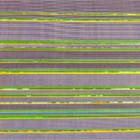
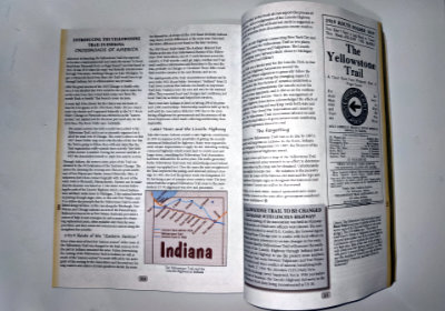
One can be seen in the picture at left. It is not, as one might reasonably guess, an image of exposed strata at a geological dig somewhere along the Trail. It is a shot of the book’s unusually colorful edge. The book’s subtitle is “A Modern Guide to Driving the Historic Yellowstone Trail 1912-1930”, and a majority of its pages are dedicated to providing that guidance through maps and mile-by-mile descriptions of the route and things beside it. There is a brown-edged guide section for each of the thirteen states through which the Yellowstone Trail passed. Those guide sections also contain what the authors call “History Bits” on a gravel background that appears mottled at the edges. These pages contain old newspaper articles, driving notes, and other items. Preceding each guide section is a yellow-edged introduction to the state. Green-edged pages contain history and other information that does not apply to a single state. Although I have no field experience with this color coding, it strikes me as something that cannot help but make it quicker to access a specific subject or map.
All those colors also serve to indicate that the book goes well beyond its subtitle. I wasn’t totally oblivious to that in my earlier looks but with those, I had been almost entirely concerned with where to go. With relaxed navigational needs, those yellow and green pages got a lot more attention and I found them quite interesting. They make good reading even if you have no intention of ever driving a single mile of Yellowstone Trail. In fact, not every item on them is directly tied to the YT. Plenty of interesting information and stories about the early days of auto travel appears on these pages and on some of those gravel pages, too.
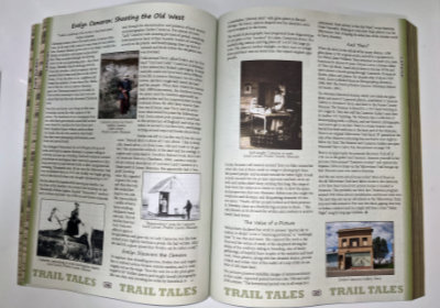
As can be seen, there are tons of photos in the book. They are in color on non-gloss paper. Most are rather small but all are clear and large enough to serve their purpose. Sure, it might be nice to see some of these images as 8 by 10 glossies but this is a book to use not to lay on a coffee table. The paper choice helps keep the book’s price reasonable and the image size allows more to be included. Good choices, I’d say.
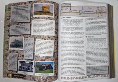
I guess you could say that the gravel and brown pages are the reasons for the book’s existence. They make up that “Modern Guide to Driving the Yellowstone Trail”. It is these pages that I have actually used in the past and I found them accurate and informative. Note that, although “History Bits” and “Mile-By-Mile” pages are interspersed, all “Mile-By-Mile” pages are on the right-hand side and no individual entry is split across pages. This is just one example of the author’s remarkable attention to detail.
The whole book is organized from west to east. The state chapters go from Washington to Massachuttes and mileages given within the chapters are from the state’s western border. An ordering from east to west is probably more common in route guides, but there is certainly nothing magical about it. Primary maps use a uniform four-miles-per-inch scale with each typically covering something around 20-30 miles. They are augmented with higher precision insets when needed, and low-resolution full state maps show where each section map fits within the state.
I have encountered guides that contain turn-by-turn directions and almost nothing more. As a solo traveler, I can appreciate such guides because they make it easy to stay on the route. They also make it easy to miss some point of interest. That does not describe this guide. Using it requires either significant preplanning, a navigator, or frequent review. It may seem like I’m saying that’s a bad thing although I definitely am not. I want good information and I’ll deal with it through preplanning and frequent stops.
The Ridges have been researching the Yellowstone Trail since the mid-1990s. In 2003, they helped form the modern Yellowstone Trail Association and currently serve on its board. They published the 96-page Introducing the Yellowstone Trail in 2000 and probably almost immediately began thinking of this larger guide. That sounds like a long time to research a subject but this subject is over 3,600 miles long and the fact that the records of the original Yellowstone Trail Association were destroyed in 1930 when it ceased operation sure didn’t make it any easier. The Ridges have used that time well and brought together an incredible amount of information on the route’s history as well as its path which they share in a book they call an invitation.
The yellow-edged introduction to South Dakota ends with an invitation to “…enjoy the Trail through the state…”, and there are other invitations in the book as well. The big one, however, is in the very first sentence of the preface. “This book is an invitation to take, by auto or armchair, the Great American Road Trip along the nearly forgotten but historically important Yellowstone Trail.” I invite you to first acquire then accept John and Alice’s invitation. I’m doing it from an armchair right now but I’m ready to do it by auto despite the fact that I did it a few months ago. I’m always ready to repeat a trip, of course, and I always discover things I missed the instant a trip ends. But not like this.
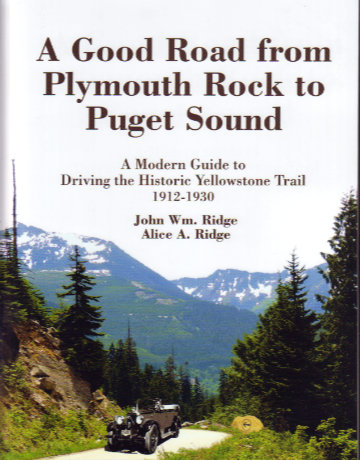
A Good Road from Plymouth Rock to Puget Sound: A Modern Guide to Driving the Historic Yellowstone Trail 1912-1930, John Wm. Ridge and Alice A. Ridge, Yellowstone Trail Publishers (July 2021), 8.5 x 11 inches, 428 pages, ISBN 978-0-9702832-5-2, Available through the Yellowstone Trail Association.
 Just like all but one of my previous books, Tracing a T to Tampa is a travelogue. Unlike any of those books, it is not about following a specific road or reaching specific destinations. It is about following a single specific trip. That trip is one made by my great-grandparents in 1920 in a Model T Ford. Throughout the 1920 journey, my great-grandmother sent a series of letters to her daughter in which town names were often included in her reports of what they were seeing and doing. Those town names allowed me to roughly reproduce their route. There are multiple reasons why my reproduction is a rough one. One is that roads have changed in the intervening years and another is that I usually had to guess at the path they took between the towns my great-grandmother mentioned. Some of those guesses are almost certainly wrong but proving it, should you be so inclined, would not be easy. Parts of the 1920 trip were clearly on the Dixie Highway and National Old Trails Road although neither is identified by name in the letters.
 If I maintained a list of questions I frequently ask myself, “Why another Route 66 book?”, would be high on the list. I have never arrived at a reason that another one is actually needed; only justifications for ones at hand. Those justifications generally take the form of answers to two questions. They are, “What makes this book different from all others?”, and “Why should I buy it?” In practice, I ask them in the reverse order which means that, if I don’t have a good reason to buy a book, I’ll probably never get around to discovering what, if anything, makes it different.
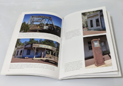 Although not of the coffee table variety, this is first and foremost a photo book. It contains upward of a hundred photographs, in color, printed on good quality semi-gloss paper. They are primarily documentary photos. That does not mean that they are boring, but it does mean that properly recording each subject is the main goal. The book is certainly not without its share of creative composition, but there are no abstract-light-patterns-on-pavement style pictures. There are usually two or more photos on a page for a max size somewhere around 5.5 by 3.5 inches. That might keep you from displaying it on your coffee table, but it is plenty big enough to show off bridges, buildings, and signs.
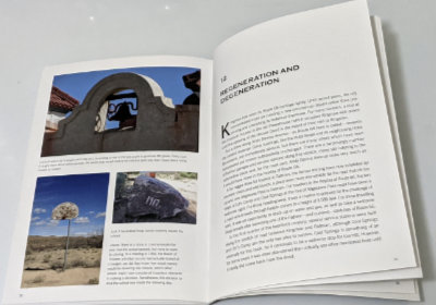 Yes, the pictures are cool and those of some fairly obscure places enlightening, but it is the words that made me happy with my purchase. The histories of most of the pictured buildings are told. Some are reasonably well known and available elsewhere, but Miller’s telling is both complete and concise. Others are not so well known, and I’ve little doubt that Miller’s aforementioned sleuthing ability brought out some details and possibly some entire stories. Maybe others knew all those details about the schools of Valentine, but I sure didn’t, and the story of the Ostermans and Peach Springs was all new to me. There are other examples of what I take to be sleuthing in the book, and all of them add to my appreciation of it.
 I knew nothing of this book or its author until just before it was reviewed in the Jefferson Highway Association newsletter, The Declaration. The only reason I learned of it that early was because the reviewer, Wayne Shannon, is a friend whom I happened to chat with by phone while he was putting his review together. He was quite positive in talking about the book but, like me, unfamiliar with the name Stephen H. Provost.
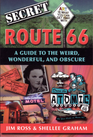 At first glance, this probably looks like a perfect fit for my bookshelf. Like many of the other books there, its subject is a historic highway and its authors are people I know. In this case, the highway is Route 66 and the people are the husband-and-wife team of Jim Ross and Shellee Graham. Both are accomplished historians, photographers, and writers with Jim probably having a bit of an edge in the history department, Shellee having an equally small lead on the photography side, and their writing skills being too close to call. A second glance, however, just might turn up something about this book that is different from most of the others with which it now shares shelf space. It is the word “secret”.
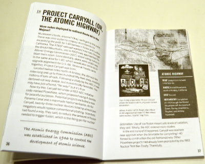 So how is this book I didn’t exactly want? Surprisingly good. I’m not really all that surprised, of course. To my relief, the idea of revealing secrets doesn’t get much further than the title. I doubted that a pair of respected authorities would suddenly become conspiratorial sounding characters sharing dark secrets from the shadows but it was good to have that verified. To some extent, the subtitle also does that. Weird, wonderful, and obscure accurately describe the book’s contents.
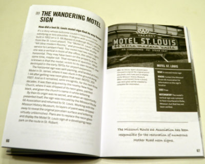 Almost everything in Secret Route 66: A Guide to the Weird, Wonderful, and Obscure is something that, while not actually a secret, is not likely to be found in mainstream guides. Even when the subject is something commonly known, Ross and Graham provide some detail or backstory not commonly known at all. Sometimes the subject isn’t a place or a thing but simply that uncommon detail or story. Among the things that struck me as weird is the true tale of a proposal to use atomic bombs for roadway excavation. Everyone has their own definition of wonderful but my definition is matched by the story of the Motel St. Louis sign that wandered off to help people find another motel (Finn’s in St. James) and then a church (New Hope) before being rescued and returned home. I thought learning about the annual reunion for the ghost town of Alanreed was kind of wonderful, too. Topping my personal list of obscure things is the chapter on several abandoned bridge abutments on the original route through Santa Fe.
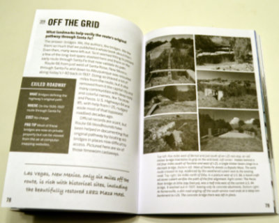 A pair of facing pages make up each of the ninety chapters so that everything about an item can be studied without flipping back and forth. A sidebar contains appropriate information, such as location. These pages are printed in black and white, but they are augmented by sixteen pages of color photographs (plus 2 b&w to make the positioning work) in the middle of the book. Some page flipping here is appropriate but the subject and associated page number are shown for each photo to make it easy. Images in the book are a mixture of historic and modern. Most of the modern photos are the work of the authors but not all. Other researchers and photographers are always credited with images provided.
 I guess my purchase of this book fits the technical description of an impulse buy, but I sure don’t think of it that way. Yes, I bought it without a hint of hesitation the instant I learned of its existence and there was certainly a lot more emotion than logic involved in the decision. But I sincerely believe that the logical part of my brain had long ago decided that acquiring this book was something I needed to do as soon as it existed. If it ever did.
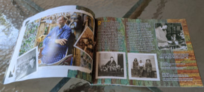 Sometime between the book being ordered and its arrival, I revisited its description and noticed its length of thirty-six pages. I wasn’t worried but I did wonder how Carla could tell Ross’ story in just three dozen pages. The answer, as I think I already knew, is “Just fine.” She tells it with pictures and just enough well-chosen words to properly place those pictures in Ross Ward’s life and to tell some details of that life that the pictures do not.
 There are several delightful photos of Ward, but the bulk are of his art and the bulk of those are in a section of “2D Work”. It’s a section I found quite interesting as most of its contents are things not displayed at Tinkertown. Items range from posters to etchings to fine art paintings representing nearly every period in Ward’s life. A personal favorite is a circus parade that he drew on thirty feet of adding machine paper at the age of eight.
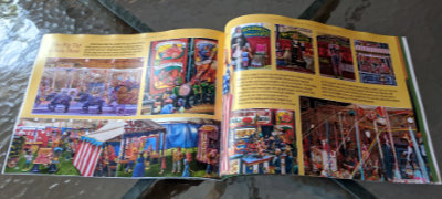 A “Tinkertown” section follows. The pictures in it are of things I’ve seen but that doesn’t make me enjoy it any less. The well-done photos provide an excellent look at the exhibits that got me interested in Ross Ward to begin with. A timeline of Ross Ward’s life appears on the final page.
  The subject of
 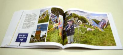 The bonus section comes first. “Roadside Art Parks” documents seven of the more famous examples of the genre with quite a few pictures of each. I got an exaggerated opinion of my own worldliness when I counted two of the first three as ones I’d visited. I was put back in my proper place when I ended the section with a score of 3 out of 7.
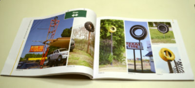 The “high” of the subtitle appears next in “Things-On-A-Pole”. I’d quickly learned my lesson and made no attempt to count and compare what I’d seen. In addition to tires, there are pictures of elevated fish, airplanes, cars, trucks, boats, etc. Et cetera includes a category labeled “Stuff”.
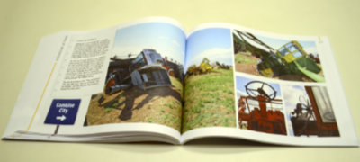 In addition to famous installations such as Cadillac Ranch, Carhenge, and the sadly vanished Airstream Ranch, “Half-Buried” includes quite a few of the not so well known examples of things poking out of the ground. The pages pictured at left show a personal favorite. When I visited Combine City in 2007, there were ten retired machines planted in the Texas field. There are fourteen in O’Brien’s description so it apparently kept growing for at least a while. On the other hand, the dedicated website that existed in 2007 has gone missing.
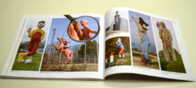 Section four, “Roadside Giants” fulfills the promise of the subtitle’s “huge”. There are subcategories like animals, donuts, people, and the ever-popular stuff. The donuts category offers a find-the-bagel challenge you can play at home.
 I started off my recent
  There’s not much point in counting the number of books published about Route 66; The likelihood that the count would increase before you were done is just too great. An Amazon search simply says “over 2,000”. So why review this one? What sets it apart from the others? The most obvious reason for reviewing it is a simple one: I know one of the people whose name is on the cover. The things that set it apart are not as obvious (or benignly biased). In fact, I’ve only found one thing about the book that I think is actually unique, and I’m not really sure about that. The book has no author; It has a narrator.
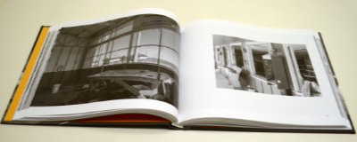 The photos are black and white, which is unusual but not unique. What may be unique is how they came to be at all. Klinkel tells that story in the book’s preface. It begins in 2013. She lives in Germany and was in the western U.S. with her husband for a four-week vacation which she describes as “the first time I ever had a serious camera in my hands”. Planned visits to several national parks fell victim to the sixteen-day government shutdown in October of that year and driving a portion of Route 66 was substituted. Klinkel credits this very first time on the historic highway coupled with the “serious camera” as having “instantly sparked my passion for photography”.
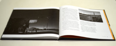 Most, but far from all, of the photos are of places I recognize from my own travels on Sixty-Six, and some of those nearly reproduce visions I’ve had myself. There are plenty of pictures of places I do not recognize. Sometimes that’s because they are from a location where I’ve never stopped or maybe even passed, but sometimes it’s because Klinkel sees and shares a vision that never occurred to me even though I’ve stood at or near the very spot she did. I don’t mean to imply that I expected anything else. It’s great to be shown something you’ve never seen, but it can be even better to be shown something known in a new way. Although it is a place I instantly recognized, a favorite example of being shown something in a new way is the early morning shot of the Bagdad Cafe with the coming sun just a tiny but significant twinkle. Another is the low-level shot of a protective wall of tires at a long-abandoned gas station at Texas Exit 0 of I-40.
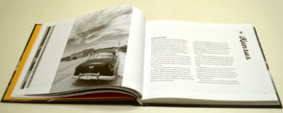 However, something clicked on a rereading of that preface that hadn’t quite registered on the first pass. Klinkel explains the title quite clearly:
 I didn’t actually try to produce a flashback last week but I thought about it. Because I’d pre-ordered the CD, when Willie Nile released World War Willie back in 2016, I got a digital copy before the actual CD arrived. It was early spring and I took a nice walk around the neighborhood with the new music playing in my ears. The walk and the songs both made an impression. A similar situation existed with New York at Night. A digital version became available before the physical version arrived. My World War Willie introductory walkabout was powered by a 2011 vintage iPod. It still works fine but I no longer have any way to maintain its contents. This time I downloaded the music to my phone and set out to enjoy some fine weather and new music.