Book Review
Border to Border on US Route 89
James Cowlin

US-89-Photography-Guide-CoverWhen I first glanced at the title of James Cowlin’s latest ebook, I’m pretty sure I expected it to contain advice on exposure and filters and other photographic folderol. But a more thoughtful reading of the carefully constructed title yielded a different impression. Just as the title says, Border to Border on US Route 89; A photographer’s guide to America’s most scenic highway is not a guide to photography. It’s a guide to a highway.

It was written by a very accomplished photographer and other photographers, even some as good as Cowlin himself, can benefit from it. But, at its heart, the book is simply a guide to Cowlin’s beloved US 89 written — and illustrated — from a photographer’s point of view.

The book is organized around thirty photos taken in the spring of 2010 as the Cowlinses (Jim and wife Barbara) traveled the highway from Mexico to Canada. Each beautiful photograph is accompanied by a few lines of text which typically tell something about the subject as well as something about the photo. But that something about the photo is not F stops and focal lengths. It’s generally just Jim explaining what he saw and tried to capture.

The photos appear, each on its own page, in south to north sequence. Cowlin sees three geographic regions along the route and a couple of pages of description precede the photos from each region. These pages provide a little background, give some idea of what might be seen there, from the 58 kinds of reptiles and amphibians in southern Arizona to the glaciers at the Canadian border, and identify some favorite photo ops.

The book does not contain detailed instructions for driving the route or for duplicating the wonderful pictures. It does contain an excellent overview of the road that Cowlin calls “America’s most scenic Highway”. He lets slip the real purpose of the book in the forward when he says “I do hope that this guide will inspire you to take a road trip on US Route 89.” The book definitely contains a lot of inspiration.

James Cowlin is the founder of US Route 89 Appreciation Society. Border to Border on US Route 89; A photographer’s guide to America’s most scenic highway can be purchased here. A Road Trip Map Book is available here.


Deciding that book reviews were a good fit for this blog instantly put me way behind. If I posted them on Sundays when there was nothing more pressing it might take me months just to squeeze out the half-dozen or so already on the list. To keep that from happening, I’m going to post book reviews on Wednesdays for the next few weeks and leave Sundays for whatever.

Book Review
Ghost Towns of Route 66
Jim Hinckley

Last week’s visit to Fort Recovery was triggered by a book. That book, a new one on the 1791 Battle of the Wabash, was available (pre-release) and its author, in addition to autographing copies, gave a presentation on the battle. As I wrote the blog entry about the visit, I was simultaneously struck by the idea of reviewing the book and the realization that book reviews might make good subjects for blog entries. I’ve recently picked up a few new books including some by people I know and to whom I’ve promised some feedback. Reviews, it seemed to me, would be a good way to feed the blog and focus the feedback. So here is the first book review entry. I promise there will be more.

Ghost Towns of Route 66The subject of this review is a book I picked up from the author, Jim Hinckley, when I passed through Kingman, Arizona, in June. Ghost Towns of Route 66, is the second Hinckley product I’ve read. The first was Route 66 Backroadswhere I was at least as impressed with the photography as with the writing. That is true of the newer book as well. …Backroads used photos from Kerrick James and Rick & Nora Bowers along with some from outside sources. James is the only photographer listed on the cover of Ghost Towns… although there are a few by others including Hinckley. My praise for the photos is not intended to diminish Hinckley’s writing but to recognize some wonderful images and acknowledge a huge reason that these books get a second look when spotted on a store shelf or counter.

Ghost towns is a subject where photos and words can truly complement each other. By definition, a ghost town is a place that was once thriving but is no longer. When you visit a ghost town, you look at what remains and try to imagine what once was. James’ pictures let you see what remains and Hinckley’s words help you imagine what was there once upon a time.

Hinkley’s words are the result of some serious research. The man definitely does his home work. Facts about a town’s beginning are usually given and the events and circumstances leading to its rise and fall are discussed. Some of the falls are complete while others are far from it.

A few towns on Sixty-Six do match the far west ghost town image of complete  desolation with nothing moving but tumble weeds. Those that do, like Allanreed in Texas, Endee in New Mexico, and Glen Rio on the state line between them, tend to be a bit to the west themselves. Other towns that Hinckley has included, such as Galena in Kansas and Afton in Oklahoma, ain’t dead yet.

In fact, Galena and Afton are current must-stops on any Route 66 trip through the area. In Galena, 4 Women on the Route has become a major roadside attraction in just a few years and in Afton, Laurel Kane’s Afton Station, established a bit ahead of 4 Women…, is a true Route 66 icon. But Hinckley isn’t to be faulted for including these towns. Both are mere shadows of their boom time selves. The decline has currently ceased and maybe even reversed but there was sure a lot of it and there is no guarantee that it isn’t just paused.

This isn’t the first book one should acquire when planning a drive down Historic Route 66. In my opinion, that spot belongs to Jerry McClanahan’s EZ 66 Guide and there are other route related books offering a broader view of the road and the attractions at its side. But, if you are attracted to clusters of dilapidated buildings and often wonder what a wide spot in the road used to be, Ghost Towns of Route 66 could be just the book you want. You’ll get lots of history and some great photos of many un- and under-populated
settlements along the historic highway.

Ghost Towns of Route 66, Jim Hinckley and Kerrick James, Voyageur Press, June 2011, 10.25 x 8.75 inches, 160 pages, ISBN 978-0760338438
Available through Amazon.


Viva la Mush or rebellion in the heartland. I like fried mush. It reminds me of my childhood. The fact that Bob Evans restaurants served this breakfast staple accounted for many — perhaps even most — of my visits there. Last month, when my local Bob Evans informed me that mush was no longer available, I was heartbroken. When this came up in a conversation with my sister, she told me that, although it was no longer on the menu, fried mush could still be had at the Bob Evans in Greenville, Ohio, if you asked. I stopped in to make sure she wasn’t just teasing me and found that, not only was it available, it had been returned to the menu. I told the cashier how I had been forced to come there because my own Bob Evans had dropped my favorite and she told me they had tried that, too, “but it didn’t go over very well.” After a week or two mush was returned and it reappeared on the menu at the next printing. Viva la mush and viva the small town restaurant manager who keeps her customers happy in spite of corporate directives.

Old Fort and Young Chicken

That’s my sister and me in the lock-up at Fort Recovery sometime in the mid-1950s. From about age six to age ten or so, the site of the 18th century fort was my favorite “vacation” spot. During those years, a summer was not complete until I’d talked my parents into taking us to this far away and ancient attraction. In time I learned that the log structures were not the originals from 1794. Those were already long gone when a 1938 WPA project produced the one-third sized replica that was there on my first visit. The building we’re peering out of was part of the replacement constructed toward the end of my fascination. A worker at the museum thought 1957 or ’58. Eventually I even learned that this particular “far away” was something less than fifteen miles north on the very road we lived on. Figuring that out took me awhile since all other travels — school, shopping, relatives, Dad’s job — were in some other direction. I still greatly appreciate my parents taking me there even if the effort wasn’t quite as extreme as I once thought.

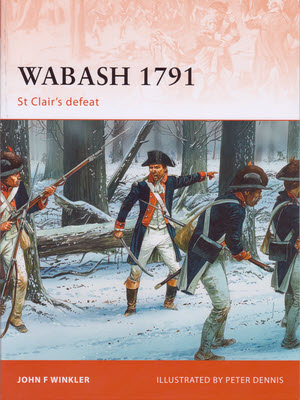
I mention this now because I stopped by the old fort today. I was near my childhood home for other reasons and there were some happenings at the fort centered around a new book titled Wabash 1791: St. Clair’s Defeat. Yesterday John Winkler, the book’s author, led a walk around the site for educators. Today he gave a pair of talks. I was there well ahead of the first talk at 3:00 but didn’t move to the lecture room until it was filled to overflowing. I did get a good seat for the slightly less crowded 4:00 presentation.

St. Clair’s Defeat, a.k.a., The Battle of the Wabash, occurred 220 years ago last Friday. On November 4, 1791, St. Clair’s 920 men were attacked at the future site of Fort Recovery by a slightly larger force of Miami, Shawnee, and Delaware Indians. The result was pretty much a massacre with 632 soldiers and all or nearly all of the approximately 200 camp followers killed. I’ve seen conflicting statements that the dead soldiers represented a quarter of the U.S. Army at that date and that the battle reduced the U.S. Army to around 300 men. I’m guessing that the discrepancy comes from varying counts of deserters and the sick. I picked up a copy of Winkler’s book so maybe I’ll find the accurate numbers there. Regardless of how much Army remained, much clearly didn’t. By several different measures, this battle was the worst defeat in United States history.

Just over two years later, troops under “Mad” Anthony Wayne began construction of what they would name Fort Recovery. It was completed in March of 1794 and in June of that year survived attack by what has been called the largest force of American Indians ever gathered east of the Mississippi. That was followed by Wayne’s victory at Fallen Timbers which was followed by the Treaty of Greenville which was followed by the state of Ohio.

When I did an Oddment page for the 2010 Fair at New Boston which included a reenactment of the Battle of Fallen Timbers, I discovered that a song existed about St Clair’s Defeat. A recording by Roger McQuinn, complete with lyrics, can be heard or downloaded here.

Anthony Wayne was my childhood hero. I imagine part of the reason was the “Mad” in his name but I was really impressed with that cocked hat. When I saw my first picture of a bare-headed “Mad” Anthony, the general came near to losing me as a fan. But I overcame the shock and stuck by my hero and still enjoy knowing that he and I ran up and down the same roads separated by just a couple of centuries.

Of course, sis and I did eventually get out of the frontier hoosegow but it happened again.

I was alerted to the Fort Recovery doings by a Ohio Historical Society newsletter. Just a couple of days prior, the Lincoln Highway Facebook group had a link to this article on Balyeat’s Coffee Shop in Van Wert, Ohio. I’ve eaten at Balyeat’s multiple times but have never had the “Young Fried Chicken” advertised on their wonderful neon sign. The Facebook post reminded me of that and, since Van Wert and Fort Recovery are only about thirty crow miles (or forty Subaru miles) apart, I decided to correct that gap in my experience. Today the chicken is baked rather than fried but I’m sure it’s still young.


I have now removed the forum that was added in 2010. I said I would do that in the very first entry of this blog but I saw no need to rush. Until this week, it has sat there idle exactly as it had for the seven preceding months. Every now and then some spammer would attempt to set up an account but they were few and far between. But this week there has been a mini-flurry (6) from folks with names like “Okkgeiwk” and “horrhyday” which prompted me to finally delete the thing.

My Gear – Chapter 3
Garmin GPS III Plus

The Garmin GPS III Plus was pretty high-end for a personal GPS in 1999. In July of that year, this baby set me back a whopping $355. Some rather detailed maps could be downloaded to it and it could tell you where things were relative to where you were but it couldn’t tell you how to get there. I’m fairly certain that there was a GPS IV that offered routing but I can find nothing online about it. Today’s web claims that the earliest GPS of this style that did routing was the GPS V. The GPS V was described as a “versatile navigator”. The III Plus merely had “cartographic capabilities”. I always thought of it as an automatically scrolling map.

I added a cable that allowed me to simultaneously connect it to the car’s 12 VDC cigarette lighter and to a computer’s RS-232 port. It was another one of those “computer in the car” things that rarely got used. I used the 12 VDC power almost constantly and I used the computer connection frequently but seldom at the same time. The frequent use of the computer connection was because the unit really wouldn’t hold much more than a day’s worth of maps and my end of day tasks often included refreshing the maps in the Garmin. Throw in a little expressway travel and it was entirely possible to “over drive” the loaded maps in a day. I did not buy an optional mount for the unit and got by quite nicely with a bit of velcro on the console.

You could select cities and other points of interest and the III Plus would point toward them and tell you how far away they were. If you chose one to “Go To” it would continuously report the remaining distance and time. Since the distance was “as the crow flies”, it and the time to go were only meaningful if the road between here and there was a straight one. I’m not really sure what it used to calculate that time to go; A rolling average speed is my guess. You could string together multiple way-points in what the III Plus called routes and it would provide total distance and time numbers based on straight lines between the way-points. This was essentially a fancy hiker’s handheld unit with the aforementioned “cartographic capabilities”.

The GPS III Plus led me to a style of navigating I called “jagging”. When I wasn’t following a specific route, like Historic Route 66, I would plug in a destination then head toward it. At each intersection, I’d make the decision of which way to go based on the direction of the destination from that point. You might think that would result in the shortest path but real roads are neither particularly straight or aligned squarely with others. “Jagging” put me on some interesting roads I might never have traveled otherwise.

My Gear – Chapter 2 — Toshiba Libretto


The three items at the heart of my road trip tool kit are a digital camera, a portable computer, and a GPS receiver. My first such set, the one used on that 1999 Route 66 road trip, consisted of this Garmin receiver along with the Agfa camera and Toshiba sub-notebook described earlier. Future purchases would be upgrades or replacements.


The blog post about the 100th trip pointed to a collage of 100 thumbnails representing them all. Just looking at that collage would bring a smile to my face for the first dozen times or so. But then I got questions about what the subjects were or what trip they represented. I knew all the answers but I quickly realized that the collage could really be improved. When an individual image appears on the home page, the subject and the trip it is from are identified beneath it. Clicking on the picture goes to the associated trip report. I decided that it would be cool if the collage did the same thing so now it does. Hovering over a section of the collage will reveal trip number and name and the identity of the subject. Clicking will take you to the trip report. Try it out here.

Feedburner? Fuhgeddaboudit.

Two months ago, when this blog was just a couple of weeks old, I made a post confessing to underestimating the power of a WordPress plug-in to provide email notifications. In this one, I’m confessing to overestimating the ability of Feedburner to do it. Technically, I suppose I didn’t actually overestimate its abilities but I think I overestimated its dependability and relevance. At the time of that first confession, I switched to the plug-in and stopped promoting Feedburner. I didn’t worry about any subscriptions already in place and assumed they would just keep going. That assumption was reinforced by the fact that my own test subscription continued to work. I was in “set it and forget it” mode regarding Feedburner.

Then, just a few days ago, I was doing some general website maintenance and decided to look in on my Feedburner account. It must still be there — at least one subscription is working — but I can’t login to it. Google bought Feedburner back in 2007 so you would think that all the “moving” associated with the change in owners had occurred long before I came along in 2011. Guess not. Feedburner.com is redirected to a Google address where I am invited to “Claim your feeds now” and I’ve tried. One needs to submit one’s Feedburner username and password to do that and I’m told that those I’m submitting are “incorrect”. My note keeping isn’t the best and my memory’s worse so I suppose that’s possible. But when I enter an email address to recover my forgotten password, I’m told it is “not found”. I’m pretty sure I know my own email address so I’m suddenly not so ready to believe that all of the problem is all on my side of the screen.

Google offers some FAQ style “help” for Feedburner but there is no contact information for support. Of course, actually reaching support for anything Google related is a challenge but Google does provide forums where we can “talk among ourselves”. They are divided by product or service and there are more than forty of them. There is one for “Web Search”, and for “Toolbar”, “Picasa”, “Google Earth”, and so on. Tellingly, there is none for Feedburner. Using that Google “Web Search” thing to dig around the internet turned up several indications that Google’s acquisition of Feedburner may not have been such a good thing for Feedburner users.

I’m sorry. Had I initially understood that I could provide email notification of posts directly, I’d never have embraced Feedburner. Now I can’t even login to let go. Plus I have no faith that any Feedburner subscription other than my own is working. At least one certainly is not.

I recalled that long time trip report reader (and sometimes much appreciated proofreader) Laurel Kane had subscribed following my first blog post. At that time I could still login to Feedburner so I’m pretty sure things started off OK. I dropped Laurel a note and learned that she hadn’t seen email from my blog for a long time. I know that there were only four or five subscribers back when I could see my Feedburner account and I doubt that any have been added since I dropped the link from the blog page. If, by some strange means, any of those are still working, I strongly suggest unsubscribing. I am officially announcing that The Blog At Denny G’s Road Trips and Feedburner are no longer pals.

Anyone desiring email notification of new blog posts, should enter their address in the field to the right of this blog’s home page and hit “Subscribe”. That’s regardless of whether you were an original Feedburner subscriber or not.


I’ve been kind of struggling with the relationship between this blog and the trip reports. Here is what I’m currently thinking. The blog is not confined to road trips. I intend to post to the blog at least once a week on Sunday. I want to have a blog post associated with each trip or oddment to provide a place to comment on that trip or oddment. To date, when I’ve been on the road on a Sunday, I’ve posted something trip related as a sort of placeholder. This has resulted in multiple blog posts for a trip and some are rather silly. From now on, each Sunday post will be a “real” one and each trip or oddment will get a single post. If something occurs during the week that I think interesting and I have time to write it up, that will be the Sunday post. If not, I’ll use a canned article like those in the “My Gear” series. When a trip starts on a Sunday, there just might be two posts for that day. I’ve always said that once a week was the lower not upper limit.

My Gear – Chapter 2
Toshiba Libretto

Toshiba Libretto CT50My first portable computer was a Toshiba Libretto 50CT. This was a truly small machine for its day with a weight of 1.87 pounds (with battery) and dimensions of 8.27″L x 4.53″W x 1.34”H. It had a 6.1″ screen, a 770 MB hard disk, 16 MB of RAM, and a 75 MHz Intel Pentium processor running Windows 95. Perhaps its most unusual feature was the built in pointing device. It’s a button to the right of the screen that you move with your thumb while your fingers fall on two buttons on the back of the screen for “clicking”. It may sound awkward but was very natural and I liked it. Toshiba called this AccuPoint and claimed it as a trade mark. A search for it today shows it as the registered name of brand of hunting scopes.

I was kind of shocked when I looked back and saw that I paid $535 for a used Libretto in June of 1999. I guess that price was at least partially justified by the inclusion of a CD drive that connected through and was actually powered by the Libretto’s PCMCIA slot. In July I shelled out another $85 for a 12 VDC cable.

I had visions of using the computer in the car but that didn’t happen much. I planned on having company for that first trip but circumstances had me driving alone much of the time. Then, when I did have a partner, there were other things to do plus I quickly learned that reading a computer screen in a sunlit convertible isn’t all that easy. The only time I recall actually producing anything while moving was when replacing a damaged tire had us on the road after dark cutting deep into editing time but making the screen usable.

Like the Agfa 780c camera, the Libretto did its job. I used it to retrieve photos from the camera, edit them, then upload them to the website along with text that was also produced on the Libretto. It also handled my email and web browsing. It did not, however, do all of those things at once. Some tasks filled that 16 MB of memory and others were just slow. Editing photos was both. As I switched between tasks, RAM became fragmented so that there might not be enough available to load some program. Somewhere I obtained a memory defragmenter program and I recall using it often to let me start the next task on the Libretto.

I used the Libretto for just a few trips then sold it, via eBay, for $317. By then I had acquired another PCMCIA CD but it required AC power. I offered the purchaser his choice and he went for the newer and faster AC unit. The CD would be very useful with my next computer and I still have it. I also have a Libretto 50CT. My friend John, who was the driver during that one mobile edit session, gave it to me when he bought several retiring units for about $25 each. It is running Windows 98 but is otherwise just like the one I had in 1999. I fired it up to check some things as I wrote this and the audible clicking of its hard disk as it booted sure brought back memories and my thumb felt right at home on the AccuPoint.

My Gear – Chapter 1 — Agfa ePhoto 780c

The First One Hundred

Juan DelgadilloDirk HamiltonI arrived home from a road trip on Thursday and proceeded to wrap up the online report for it just like I’d done ninety-nine times before. This was my 100th trip; A seven day 1200 mile affair that involved both expressway and two-lane, reached some big water, used mom & pop as well as lower echelon chain motels, and included a little live music, along with diners, narrow roads, long bridges, and old buildings. All in all, a most typical trip.

Collage of thumbnailsWrapping up a trip includes selecting a single image to go into the pool from which images are selected randomly for display in the upper right hand corner of this site’s home page. Appearing at the top of this blog entry are Juan Delgadillo from the first trip and Dirk Hamilton from the 100th. Click the thumbnail to the right for a collage of all one hundred.

EDIT 30-Oct-2011: The collage has been replaced with a clickable version linking each thumbnail to its associated trip report. 

The 100th trip wasn’t supposed to be quite as typical as it was. Most of its miles were supposed to be aboard a train that was cancelled at the last minute. Only one of the 100 trips has used a train for actual transportation and that trip also involved a commercial flight and an aircraft carrier. That’s atypical with a capital ‘A’. Just flying would have made that trip fairly unusual. Only eight of the first 100 trips involved an airplane.

So just how typical was that 100th trip? It clearly had many of the typical components. In addition to those listed in the first paragraph, there was some old concrete pavement, some standing stone bridges plus the remnants of one; Some museums, some art, some historic landmarks, and a lighthouse. It did not have any brick or dirt roads and there were no meetings, ceremonies, or banquets. At seven days, it was a little above the 4.74 day average. The longest of the first 100 was last spring’s Lincoln Highway Association Conference outing of 25 days. There were twenty single day trips.

The 100th trip went east whereas more trips have gone west than any other direction. The score, using Cincinnati as the hub and applying some fairly unscientific judgement calls, is west 35, east 24, south 21, and north 20.

The journal for the most recent trip is considerably denser than that first one in 1999. There are more words and a lot more pictures. The 16 day 1999 trip averaged about eight pictures a day. The just completed seven day trip averaged over 22 per day and that’s just the pictures accessed through thumbnails. Throw in those accessed by links embedded in the text, of which there were none in 1999, and the average goes above 25 per day. But the reporting of the 100th trip seems to be the current norm. Its precise averages are 25.43 per day total and 22.57 for thumbnail style only. The corresponding numbers for that record setting 25 day trip are 25.68 and 22.24.

A hundred trips in twelve years is an average of about eight a year but those first few years were pretty sparse. 1999 and 2000 had just one documented trip each and 2000’s was a day trip. The count leaped to three in 2001. The biggest years were 2004 and 2007 with 13 each. 2011 has seen eight so far. Even now, despite what some may think, I don’t really document every time I leave the driveway and there were certainly some undocumented trips in those early years.

I know there are plenty of other ways to slice and dice those 100 trips. I kind of wish I had a record of the mileage for each but I don’t. Nor do I have an accurate measure of the fun I’ve had though I’ve estimated it at infinity plus or minus two. The next 100 will surely go beyond that.

A Trip to the East

I’m on the road again so this entry will basically be a hook to hang comments on. I saw Dirk Hamilton, the subject of last week’s blog entry, last night though I didn’t arrive in DC on a train as planned. The train was canceled so the outing has turned into a more typical road trip. I got in a little bit of National Road on the way east and plan to go home on US-50. I’m curently in Ocean City. The trip journal is here.

Thug of Love

Thug of Love was Dirk Hamilton‘s fourth and (so far) last major label album and it makes a great title for a blog entry. Thug… wasn’t Dirk’s last album by any means. There have been at least ten more and the count keeps rising. But now, as then, too few people know about Dirk Hamilton and that includes readers of this website. If you know me personally, there’s a good chance you’ve heard me mention his name or play some of his recordings, but if you know me only through this website, you could only have seen his name on my “Favorite Links” page or noticed the single quote or my visit to a venue I associate with Dirk. No Road Trip or Oddment has involved Dirk himself though I guess it would have been technically possible.

Dirk Hamilton, Chris Cella, Bradley Kopp, and Denny GibsonI’ve been a huge fan since hearing Dirk’s first album at a friend’s house around 1977 but I’ve hardly ever seen him. I don’t believe he’s played in Cincinnati to this day. Dirk recalls doing a show in Dayton but that may have been before my conversion or maybe I just wasn’t paying attention. In any case, the first time I ever saw Dirk was in December of 2000. That was a decade after his self imposed exile from recording ended and two after his drive to stardom veered off course. It was in San Antonio, Texas. My girlfriend Chris and I had flown into Austin where we would see a second show two nights later. Dirk was accompanied at both of these shows by the excellent guitarist (and just generally nice guy) Bradley Kopp. That’s Dirk, Chris, Bradley, and me in the photo from that first show in San Antonio. I assure you that, despite looking disgustingly uptight in the picture, I was enjoying the hell out of meeting my idol after twenty some years.

So, theoretically, I could have documented that trip on this website. The site existed but contained only that first Route 66 trip and a day trip to Dayton. I’m pretty sure I still thought of it as something temporary.

SEXspringEVERYTHING CDIf I had documented it, a highlight of the trip would certainly have been something that happened at the show in Austin. With Bradley producing, Dirk had just completed recording a new CD. I knew of it and was quite disappointed to learn that it wasn’t yet available and wouldn’t be released until the end of January. Bummer, I thought. Missed it by that much. I’m pretty foggy on whether it was before or after the show or during a break between sets but at some point Dirk sat down beside me and slipped something my way under the table. Holy crap, I thought when I realized it was a copy of the unreleased SEXspringEVERYTHING. The disk had a plain white stick-on paper label and was in a bare-bones clam-shell case. I imagine it was created by Dirk or Bradley earlier that day. We had nothing to play it on until reaching home two nights later. The hour was late but there was no way I could sleep without hearing the entire CD. Of course, Dirk had played several of the new songs live but it was still a thrill to hear the studio versions and there were others that were completely new to us. I tried playing the CD just now after scanning it for the picture but no luck. The ten year old CD-R has simply faded to blank. But it sure was cool to listen to it back in 2000 and it still means a lot to me. It may now be nothing but a mute piece of plastic but it’s a very cool piece of plastic and I’m hanging on to it.

I’ve seen Dirk live once since then. It was less than a year later when I was visiting a friend in Dallas and Dirk was opening for someone at a coffee shop sort of place nearby. I’ve kept my library up to date with the new CDs and a concert DVD and there have been a couple of near misses but that night in Dallas in 2001 was the last time I’ve actually seen Dirk. That’s about to be remedied. Next Saturday I’ll see Dirk perform at a house concert in Jessup, Maryland. I’ll be there as part of a Road (partially railroad) Trip and expect to have a panel or two from the concert as part of the trip report. Somehow that fact seemed to justify making a blog entry out of ten year old events.


The show I’m attending in Jessup is one of a handful Dirk is doing in the eastern US. Friday’s concert at Tupelo Music Hall in New Hampshire was simulcast over the Internet. I watched, of course, and got a screen capture of Dirk and long time sideman Don Evans. I’d love to see Don but he won’t make it to Maryland.

I used phrases like “self imposed exile” and spoke of veering “off course” without elaborating. Bits and pieces of the Saga of Dirk can be found around the web but a very good and recent version is here.

Monroe’s Magnificent Mile

Solid Rock Church, Monroe, OHHustler Hollywood Store, Monroe, OHMonroe, Ohio, is a city of 12,000+ that sits on I-75 about halfway between Cincinnati and Dayton. A little more than a mile of the expressway lies within the city limits. The southern boundary is right where the northbound ramp of exit 29 begins. Turn left from that ramp and you’ll find one of Larry Flynt’s Hustler Hollywood stores doing quite well. Something of an entirely different nature is doing well at the northern edge. There, the Solid Rock Church sits just east of the expressway and east of the Monroe city limits. The huge church with its electronic billboard is definitely hard to miss, but it was even more of an eye catcher when the King of Kings statue stood there. The statue attracted national attention while it stood, and I’m sure the eyes of the world were on Monroe, Ohio, when lightning struck it in June of 2010. A different but similarly sized replacement is due to be completed by the end of this year, and the frame is already in place. Apologies for the dark and crappy picture I took from the expressway.

Treasure Aisles Flea Market, Monroe, OHTreasure Aisles Flea Market, Monroe, OHSo what lies between Monroe’s offerings of sin and salvation? Shopping. Lots and lots of shopping. Facing off across the interstate are two humongous flea markets. Treasure Aisles is on the west side inside the Monroe limits. They say this pirate-themed market is where the barrrgain hunters go. There was live music inside, although it neither looked nor sounded particularly nautical, and there was an optional gun & knife show which I skipped.

Traders World Flea Market, Monroe, OHTo the east and, like the church, just outside the city limits, is Trader’s World. The theme there might be “jungle”, though “Jungle Jim’s” seems even more accurate. Both the area’s one-of-a-kind grocery and Trader’s World have a lot of large animals prominently displayed, plus lots of stuff with no jungle connection at all. Trader’s World has murals inside and out; there’s no shortage of things to look at overhead, and antique cars and wagons are displayed in several of the unoccupied booths. No live music that I found.

I drive this stretch of I-75 a lot, so have often driven by all of these sights. All four have huge signs, and while the Hustler store isn’t visible from the expressway, its tall sign is. For the others, the signs almost seem unnecessary since pirate flags, roofs full of giraffes, and a 62-foot Jesus are all fairly successful attention getters. But despite getting my attention over and over, they never got me to stop until yesterday. I was driving by on Thursday when I was struck by the fact that this is exactly the sort of thing I chide others about: Not stopping at attractions in your own neighborhood. Maybe flea markets, churches, and porn shops aren’t typical roadside attractions, but they are using time-honored tourist trap techniques to make passers-by aware they are there.

So I visited both flea markets on Saturday. I bought some Brita filters at Treasure Aisles and a slice of pizza at Trader’s World. I haven’t decided if I’ll also visit the church and the porn shop, but if I do, I’ll probably hit both of them on the same day to see if I can spot any parishioners picking up DVDs on the way home.


Although they ever so slightly miss the limits of the actual “Magnificent Mile”, two sites just south of the city add to its magnificence. One is the recently opened Cincinnati Premium Outlets, which caters to upper-crust bargain hunters not yet ready to mingle with giraffes or pirates. The other is LB Ranch. LB is Lawrence Bishop, who is not only a very successful horse trader but the founder and Senior Pastor of the Solid Rock Church. Photos of his ranch and his church abound on the Internet, but I’ve always been fond of his silo. Before the big Jesus and the elephants and giraffes came along, the horse-topped cylinder was the biggest attraction along this stretch of interstate. At one time, the horse fell over but remained atop the silo on its side. It was returned to an upright position sometime in the last year or so, but appears to be on its last leg.